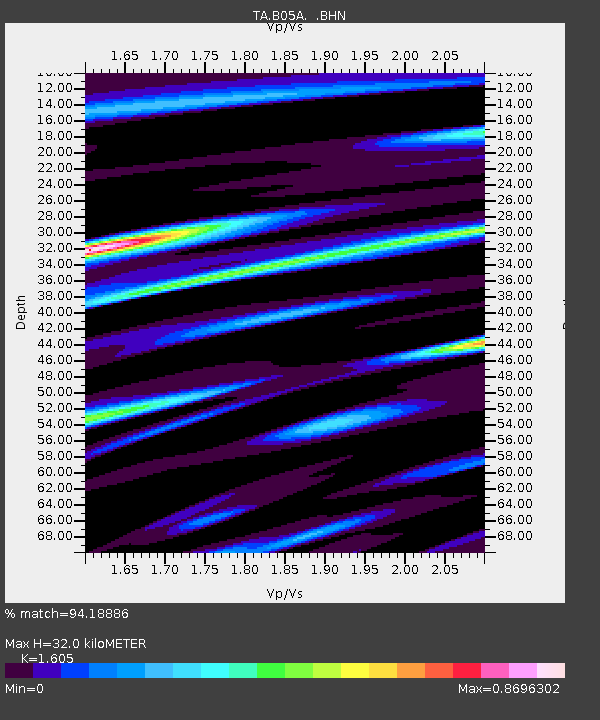
B05A Bryant, WA, USA - Earthquake Result Viewer

Earthquake location: Near West Coast Of Honshu, Japan
Earthquake latitude/longitude: 37.5/138.4
Earthquake time(UTC): 2007/07/16 (197) 01:13:22 GMT
Earthquake Depth: 12 km
Earthquake Magnitude: 6.5 MB, 6.4 MS, 6.6 MW, 6.5 MW
Earthquake Catalog/Contributor: WHDF/NEIC
Network: TA USArray Transportable Network (new EarthScope stations)
Station: B05A Bryant, WA, USA
Lat/Lon: 48.26 N/122.10 W
Elevation: 154 m
Distance: 68.6 deg
Az: 45.046 deg
Baz: 302.656 deg
Ray Param: 0.056161523
Estimated Moho Depth: 32.0 km
Estimated Crust Vp/Vs: 1.61
Assumed Crust Vp: 6.566 km/s
Estimated Crust Vs: 4.091 km/s
Estimated Crust Poisson's Ratio: 0.18
Radial Match: 94.18886 %
Radial Bump: 400
Transverse Match: 89.3372 %
Transverse Bump: 400
SOD ConfigId: 2564
Insert Time: 2010-03-06 22:55:24.407 +0000
GWidth: 2.5
Max Bumps: 400
Tol: 0.001

Signal To Noise

ChannelStoNSTALTA
TA:B05A: :BHN:20070716T01:23:54.125005Z10.7436296.308076E-75.8714573E-8
TA:B05A: :BHE:20070716T01:23:54.125005Z12.3177947.114363E-75.7756793E-8
TA:B05A: :BHZ:20070716T01:23:54.125005Z35.22872.2729948E-66.452112E-8
Arrivals
Ps3.1 SECOND
PpPs12 SECOND
PsPs/PpSs15 SECOND