You are here: Home > Network List > AV - Alaska Volcano Observatory Stations List
> Station SPCR Ckakachatna River, Mount Spurr, Alaska > Earthquake Result Viewer
SPCR Ckakachatna River, Mount Spurr, Alaska - Earthquake Result Viewer
| Earthquake location: |
Northern Peru |
| Earthquake latitude/longitude: |
-5.9/-75.3 |
| Earthquake time(UTC): |
2019/05/26 (146) 07:41:13 GMT |
| Earthquake Depth: |
105 km |
| Earthquake Magnitude: |
7.5 Mi |
| Earthquake Catalog/Contributor: |
NEIC PDE/at |
|
| Network: |
AV Alaska Volcano Observatory |
| Station: |
SPCR Ckakachatna River, Mount Spurr, Alaska |
| Lat/Lon: |
61.20 N/152.21 W |
| Elevation: |
984 m |
|
| Distance: |
88.9 deg |
| Az: |
331.852 deg |
| Baz: |
104.278 deg |
| Ray Param: |
0.04205227 |
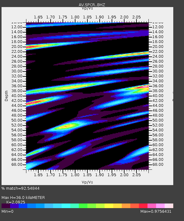
| Estimated Moho Depth: |
36.0 km |
| Estimated Crust Vp/Vs: |
2.09 |
| Assumed Crust Vp: |
6.566 km/s |
| Estimated Crust Vs: |
3.138 km/s |
| Estimated Crust Poisson's Ratio: |
0.35 |
|
| Radial Match: |
92.54844 % |
| Radial Bump: |
400 |
| Transverse Match: |
85.92269 % |
| Transverse Bump: |
400 |
| SOD ConfigId: |
18369291 |
| Insert Time: |
2019-06-09 07:42:47.450 +0000 |
| GWidth: |
2.5 |
| Max Bumps: |
400 |
| Tol: |
0.001 |
|
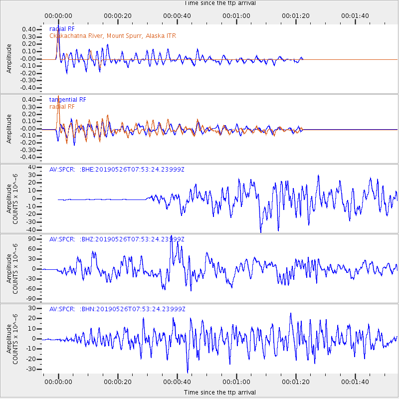
Signal To Noise
| Channel | StoN | STA | LTA |
| AV:SPCR: :BHZ:20190526T07:53:24.23999Z | 24.66624 | 7.566704E-6 | 3.0676355E-7 |
| AV:SPCR: :BHN:20190526T07:53:24.23999Z | 3.4723709 | 7.1617916E-7 | 2.0625076E-7 |
| AV:SPCR: :BHE:20190526T07:53:24.23999Z | 12.116528 | 2.8487063E-6 | 2.3510913E-7 |
| Arrivals |
| Ps | 6.1 SECOND |
| PpPs | 17 SECOND |
| PsPs/PpSs | 23 SECOND |


