You are here: Home > Network List > TA - USArray Transportable Network (new EarthScope stations) Stations List
> Station B05A Bryant, WA, USA > Earthquake Result Viewer
B05A Bryant, WA, USA - Earthquake Result Viewer
| Earthquake location: |
Samoa Islands Region |
| Earthquake latitude/longitude: |
-16.6/-172.0 |
| Earthquake time(UTC): |
2006/09/28 (271) 06:22:09 GMT |
| Earthquake Depth: |
28 km |
| Earthquake Magnitude: |
6.5 MB, 6.6 MS, 6.9 MW, 6.7 MW |
| Earthquake Catalog/Contributor: |
WHDF/NEIC |
|
| Network: |
TA USArray Transportable Network (new EarthScope stations) |
| Station: |
B05A Bryant, WA, USA |
| Lat/Lon: |
48.26 N/122.10 W |
| Elevation: |
154 m |
|
| Distance: |
78.4 deg |
| Az: |
31.471 deg |
| Baz: |
228.521 deg |
| Ray Param: |
0.049638405 |
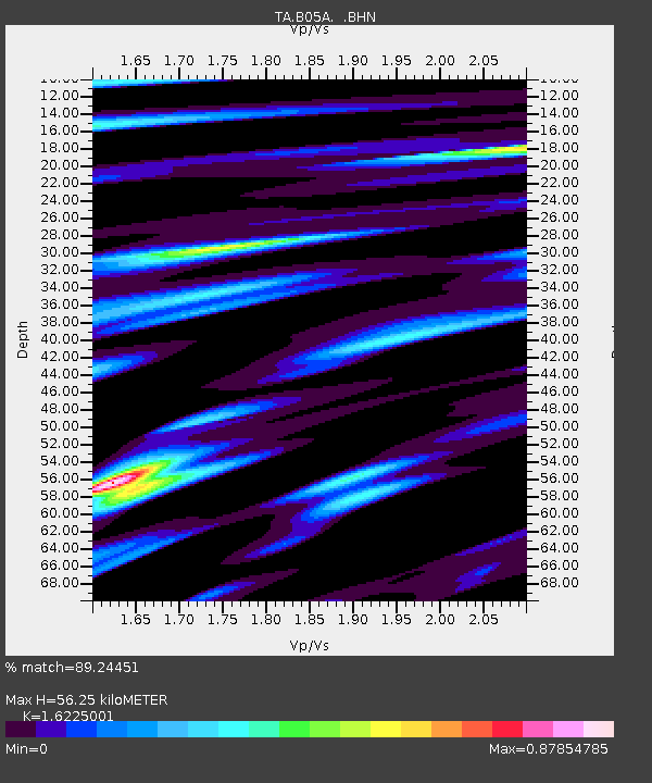
| Estimated Moho Depth: |
56.25 km |
| Estimated Crust Vp/Vs: |
1.62 |
| Assumed Crust Vp: |
6.566 km/s |
| Estimated Crust Vs: |
4.047 km/s |
| Estimated Crust Poisson's Ratio: |
0.19 |
|
| Radial Match: |
89.24451 % |
| Radial Bump: |
400 |
| Transverse Match: |
87.451195 % |
| Transverse Bump: |
400 |
| SOD ConfigId: |
2665 |
| Insert Time: |
2010-03-06 22:55:45.260 +0000 |
| GWidth: |
2.5 |
| Max Bumps: |
400 |
| Tol: |
0.001 |
|

Signal To Noise
| Channel | StoN | STA | LTA |
| TA:B05A: :BHN:20060928T06:33:36.448018Z | 7.037705 | 1.1810082E-6 | 1.6781155E-7 |
| TA:B05A: :BHE:20060928T06:33:36.448018Z | 9.705803 | 1.0338739E-6 | 1.06521206E-7 |
| TA:B05A: :BHZ:20060928T06:33:36.448018Z | 34.51144 | 4.410318E-6 | 1.2779293E-7 |
| Arrivals |
| Ps | 5.5 SECOND |
| PpPs | 22 SECOND |
| PsPs/PpSs | 27 SECOND |


