You are here: Home > Network List > TA - USArray Transportable Network (new EarthScope stations) Stations List
> Station B05A Bryant, WA, USA > Earthquake Result Viewer
B05A Bryant, WA, USA - Earthquake Result Viewer
| Earthquake location: |
Tajikistan |
| Earthquake latitude/longitude: |
39.1/71.8 |
| Earthquake time(UTC): |
2006/07/06 (187) 03:57:53 GMT |
| Earthquake Depth: |
24 km |
| Earthquake Magnitude: |
5.6 MB, 5.7 MS, 5.7 MW, 5.7 MW |
| Earthquake Catalog/Contributor: |
WHDF/NEIC |
|
| Network: |
TA USArray Transportable Network (new EarthScope stations) |
| Station: |
B05A Bryant, WA, USA |
| Lat/Lon: |
48.26 N/122.10 W |
| Elevation: |
154 m |
|
| Distance: |
92.1 deg |
| Az: |
9.256 deg |
| Baz: |
349.209 deg |
| Ray Param: |
0.04150331 |
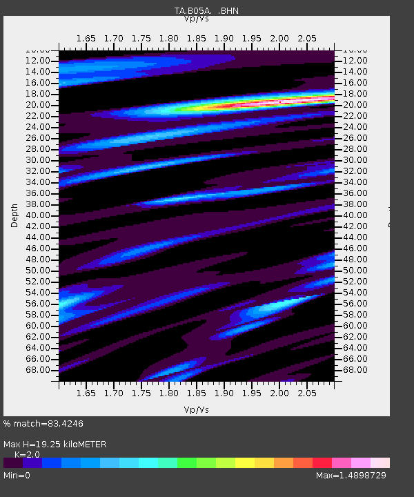
| Estimated Moho Depth: |
19.25 km |
| Estimated Crust Vp/Vs: |
2.00 |
| Assumed Crust Vp: |
6.566 km/s |
| Estimated Crust Vs: |
3.283 km/s |
| Estimated Crust Poisson's Ratio: |
0.33 |
|
| Radial Match: |
83.4246 % |
| Radial Bump: |
400 |
| Transverse Match: |
84.84066 % |
| Transverse Bump: |
400 |
| SOD ConfigId: |
2665 |
| Insert Time: |
2010-03-06 22:56:03.546 +0000 |
| GWidth: |
2.5 |
| Max Bumps: |
400 |
| Tol: |
0.001 |
|

Signal To Noise
| Channel | StoN | STA | LTA |
| TA:B05A: :BHN:20060706T04:10:29.100015Z | 5.2909317 | 1.7907948E-7 | 3.3846494E-8 |
| TA:B05A: :BHE:20060706T04:10:29.100015Z | 2.2890272 | 8.5507104E-8 | 3.7355218E-8 |
| TA:B05A: :BHZ:20060706T04:10:29.100015Z | 8.929033 | 4.7525631E-7 | 5.3225953E-8 |
| Arrivals |
| Ps | 3.0 SECOND |
| PpPs | 8.6 SECOND |
| PsPs/PpSs | 12 SECOND |


