You are here: Home > Network List > CI - Caltech Regional Seismic Network Stations List
> Station DAN Danby, California, USA > Earthquake Result Viewer
DAN Danby, California, USA - Earthquake Result Viewer
| Earthquake location: |
Northern Peru |
| Earthquake latitude/longitude: |
-5.9/-75.3 |
| Earthquake time(UTC): |
2019/05/26 (146) 07:41:13 GMT |
| Earthquake Depth: |
105 km |
| Earthquake Magnitude: |
7.5 Mi |
| Earthquake Catalog/Contributor: |
NEIC PDE/at |
|
| Network: |
CI Caltech Regional Seismic Network |
| Station: |
DAN Danby, California, USA |
| Lat/Lon: |
34.64 N/115.38 W |
| Elevation: |
398 m |
|
| Distance: |
55.3 deg |
| Az: |
319.756 deg |
| Baz: |
128.793 deg |
| Ray Param: |
0.06458702 |
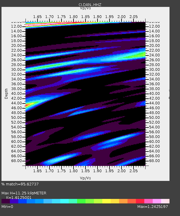
| Estimated Moho Depth: |
11.25 km |
| Estimated Crust Vp/Vs: |
1.61 |
| Assumed Crust Vp: |
6.276 km/s |
| Estimated Crust Vs: |
3.892 km/s |
| Estimated Crust Poisson's Ratio: |
0.19 |
|
| Radial Match: |
95.62737 % |
| Radial Bump: |
400 |
| Transverse Match: |
88.708015 % |
| Transverse Bump: |
400 |
| SOD ConfigId: |
18369291 |
| Insert Time: |
2019-06-09 07:44:10.665 +0000 |
| GWidth: |
2.5 |
| Max Bumps: |
400 |
| Tol: |
0.001 |
|
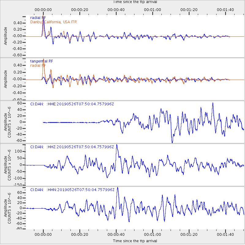
Signal To Noise
| Channel | StoN | STA | LTA |
| CI:DAN: :HHZ:20190526T07:50:04.757996Z | 30.681908 | 9.339934E-6 | 3.0441177E-7 |
| CI:DAN: :HHN:20190526T07:50:04.757996Z | 7.3758235 | 2.7634794E-6 | 3.7466725E-7 |
| CI:DAN: :HHE:20190526T07:50:04.757996Z | 10.404249 | 3.214342E-6 | 3.0894512E-7 |
| Arrivals |
| Ps | 1.2 SECOND |
| PpPs | 4.4 SECOND |
| PsPs/PpSs | 5.6 SECOND |


