You are here: Home > Network List > TA - USArray Transportable Network (new EarthScope stations) Stations List
> Station B05A Bryant, WA, USA > Earthquake Result Viewer
B05A Bryant, WA, USA - Earthquake Result Viewer
| Earthquake location: |
Fiji Islands Region |
| Earthquake latitude/longitude: |
-16.5/177.0 |
| Earthquake time(UTC): |
2006/04/07 (097) 08:30:45 GMT |
| Earthquake Depth: |
22 km |
| Earthquake Magnitude: |
5.9 MB, 6.4 MS, 6.4 MW, 6.4 MW |
| Earthquake Catalog/Contributor: |
WHDF/NEIC |
|
| Network: |
TA USArray Transportable Network (new EarthScope stations) |
| Station: |
B05A Bryant, WA, USA |
| Lat/Lon: |
48.26 N/122.10 W |
| Elevation: |
154 m |
|
| Distance: |
84.2 deg |
| Az: |
35.943 deg |
| Baz: |
237.413 deg |
| Ray Param: |
0.045626935 |
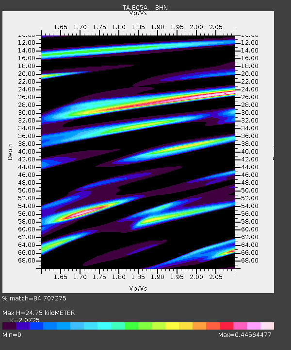
| Estimated Moho Depth: |
24.75 km |
| Estimated Crust Vp/Vs: |
2.07 |
| Assumed Crust Vp: |
6.566 km/s |
| Estimated Crust Vs: |
3.168 km/s |
| Estimated Crust Poisson's Ratio: |
0.35 |
|
| Radial Match: |
84.707275 % |
| Radial Bump: |
372 |
| Transverse Match: |
72.40511 % |
| Transverse Bump: |
400 |
| SOD ConfigId: |
2669 |
| Insert Time: |
2010-03-06 22:56:29.511 +0000 |
| GWidth: |
2.5 |
| Max Bumps: |
400 |
| Tol: |
0.001 |
|

Signal To Noise
| Channel | StoN | STA | LTA |
| TA:B05A: :BHN:20060407T08:42:44.024004Z | 0.80870414 | 1.3522747E-7 | 1.67215E-7 |
| TA:B05A: :BHE:20060407T08:42:44.024004Z | 1.3924105 | 1.702904E-7 | 1.22299E-7 |
| TA:B05A: :BHZ:20060407T08:42:44.024004Z | 4.350931 | 4.46136E-7 | 1.0253805E-7 |
| Arrivals |
| Ps | 4.1 SECOND |
| PpPs | 11 SECOND |
| PsPs/PpSs | 15 SECOND |


