You are here: Home > Network List > IU - Global Seismograph Network (GSN - IRIS/USGS) Stations List
> Station CTAO Charters Towers, Australia > Earthquake Result Viewer
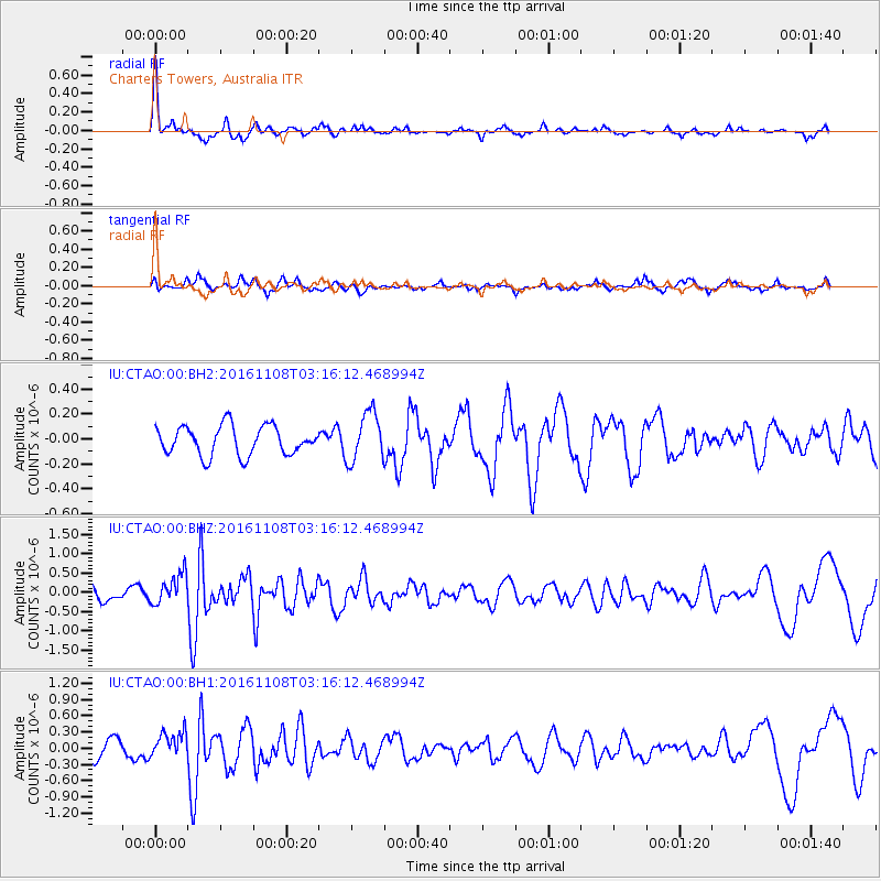
CTAO Charters Towers, Australia - Earthquake Result Viewer
*The percent match for this event was below the threshold and hence no stack was calculated.
| Earthquake location: |
West Of Macquarie Island |
| Earthquake latitude/longitude: |
-58.1/148.1 |
| Earthquake time(UTC): |
2016/11/08 (313) 03:09:25 GMT |
| Earthquake Depth: |
10 km |
| Earthquake Magnitude: |
5.7 MO |
| Earthquake Catalog/Contributor: |
NEIC PDE/NEIC ALERT |
|
| Network: |
IU Global Seismograph Network (GSN - IRIS/USGS) |
| Station: |
CTAO Charters Towers, Australia |
| Lat/Lon: |
20.09 S/146.25 E |
| Elevation: |
357 m |
|
| Distance: |
38.0 deg |
| Az: |
357.138 deg |
| Baz: |
178.385 deg |
| Ray Param: |
$rayparam |
*The percent match for this event was below the threshold and hence was not used in the summary stack. |
|
| Radial Match: |
72.852394 % |
| Radial Bump: |
297 |
| Transverse Match: |
65.18738 % |
| Transverse Bump: |
398 |
| SOD ConfigId: |
1815711 |
| Insert Time: |
2016-11-22 03:10:38.173 +0000 |
| GWidth: |
2.5 |
| Max Bumps: |
400 |
| Tol: |
0.001 |
|
Signal To Noise
| Channel | StoN | STA | LTA |
| IU:CTAO:00:BHZ:20161108T03:16:12.468994Z | 1.4883853 | 3.9375206E-7 | 2.645498E-7 |
| IU:CTAO:00:BH1:20161108T03:16:12.468994Z | 1.4738343 | 2.3995764E-7 | 1.6281182E-7 |
| IU:CTAO:00:BH2:20161108T03:16:12.468994Z | 1.6990259 | 1.9751108E-7 | 1.162496E-7 |
| Arrivals |
| Ps | |
| PpPs | |
| PsPs/PpSs | |


