You are here: Home > Network List > IU - Global Seismograph Network (GSN - IRIS/USGS) Stations List
> Station PMG Port Moresby, New Guinea > Earthquake Result Viewer
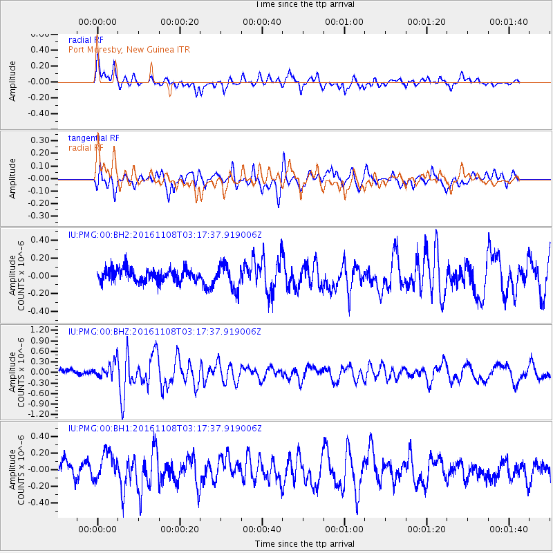
PMG Port Moresby, New Guinea - Earthquake Result Viewer
*The percent match for this event was below the threshold and hence no stack was calculated.
| Earthquake location: |
West Of Macquarie Island |
| Earthquake latitude/longitude: |
-58.1/148.1 |
| Earthquake time(UTC): |
2016/11/08 (313) 03:09:25 GMT |
| Earthquake Depth: |
10 km |
| Earthquake Magnitude: |
5.7 MO |
| Earthquake Catalog/Contributor: |
NEIC PDE/NEIC ALERT |
|
| Network: |
IU Global Seismograph Network (GSN - IRIS/USGS) |
| Station: |
PMG Port Moresby, New Guinea |
| Lat/Lon: |
9.40 S/147.16 E |
| Elevation: |
90 m |
|
| Distance: |
48.6 deg |
| Az: |
358.724 deg |
| Baz: |
179.314 deg |
| Ray Param: |
$rayparam |
*The percent match for this event was below the threshold and hence was not used in the summary stack. |
|
| Radial Match: |
65.68238 % |
| Radial Bump: |
400 |
| Transverse Match: |
67.17707 % |
| Transverse Bump: |
400 |
| SOD ConfigId: |
1815711 |
| Insert Time: |
2016-11-22 03:10:46.046 +0000 |
| GWidth: |
2.5 |
| Max Bumps: |
400 |
| Tol: |
0.001 |
|
Signal To Noise
| Channel | StoN | STA | LTA |
| IU:PMG:00:BHZ:20161108T03:17:37.919006Z | 1.7540958 | 2.4886847E-7 | 1.418785E-7 |
| IU:PMG:00:BH1:20161108T03:17:37.919006Z | 1.657155 | 1.7936156E-7 | 1.0823463E-7 |
| IU:PMG:00:BH2:20161108T03:17:37.919006Z | 1.9763063 | 1.4114357E-7 | 7.1417865E-8 |
| Arrivals |
| Ps | |
| PpPs | |
| PsPs/PpSs | |


