You are here: Home > Network List > ET - CERI Southern Appalachian seismic Network Stations List
> Station FPAL Fort Payne,AL > Earthquake Result Viewer
FPAL Fort Payne,AL - Earthquake Result Viewer
| Earthquake location: |
Northern Peru |
| Earthquake latitude/longitude: |
-5.9/-75.3 |
| Earthquake time(UTC): |
2019/05/26 (146) 07:41:13 GMT |
| Earthquake Depth: |
105 km |
| Earthquake Magnitude: |
7.5 Mi |
| Earthquake Catalog/Contributor: |
NEIC PDE/at |
|
| Network: |
ET CERI Southern Appalachian seismic Network |
| Station: |
FPAL Fort Payne,AL |
| Lat/Lon: |
34.54 N/85.61 W |
| Elevation: |
556 m |
|
| Distance: |
41.4 deg |
| Az: |
347.085 deg |
| Baz: |
164.376 deg |
| Ray Param: |
0.07345047 |
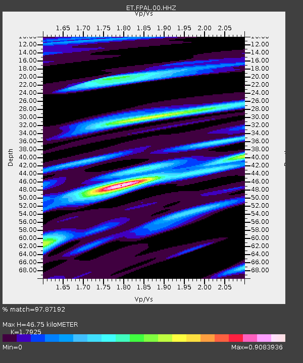
| Estimated Moho Depth: |
46.75 km |
| Estimated Crust Vp/Vs: |
1.79 |
| Assumed Crust Vp: |
6.35 km/s |
| Estimated Crust Vs: |
3.543 km/s |
| Estimated Crust Poisson's Ratio: |
0.27 |
|
| Radial Match: |
97.87192 % |
| Radial Bump: |
322 |
| Transverse Match: |
83.24976 % |
| Transverse Bump: |
400 |
| SOD ConfigId: |
18369291 |
| Insert Time: |
2019-06-09 07:46:05.186 +0000 |
| GWidth: |
2.5 |
| Max Bumps: |
400 |
| Tol: |
0.001 |
|

Signal To Noise
| Channel | StoN | STA | LTA |
| ET:FPAL:00:HHZ:20190526T07:48:18.424988Z | 22.70991 | 7.738389E-6 | 3.4074947E-7 |
| ET:FPAL:00:HHN:20190526T07:48:18.424988Z | 15.478943 | 3.901441E-6 | 2.5204827E-7 |
| ET:FPAL:00:HHE:20190526T07:48:18.424988Z | 25.953367 | 1.6550247E-6 | 6.376917E-8 |
| Arrivals |
| Ps | 6.2 SECOND |
| PpPs | 19 SECOND |
| PsPs/PpSs | 25 SECOND |


