You are here: Home > Network List > G - GEOSCOPE Stations List
> Station TAOE Taiohae, Marquises islands > Earthquake Result Viewer
TAOE Taiohae, Marquises islands - Earthquake Result Viewer
| Earthquake location: |
Northern Peru |
| Earthquake latitude/longitude: |
-5.9/-75.3 |
| Earthquake time(UTC): |
2019/05/26 (146) 07:41:13 GMT |
| Earthquake Depth: |
105 km |
| Earthquake Magnitude: |
7.5 Mi |
| Earthquake Catalog/Contributor: |
NEIC PDE/at |
|
| Network: |
G GEOSCOPE |
| Station: |
TAOE Taiohae, Marquises islands |
| Lat/Lon: |
8.85 S/140.15 W |
| Elevation: |
800 m |
|
| Distance: |
64.3 deg |
| Az: |
263.038 deg |
| Baz: |
92.306 deg |
| Ray Param: |
0.058723133 |
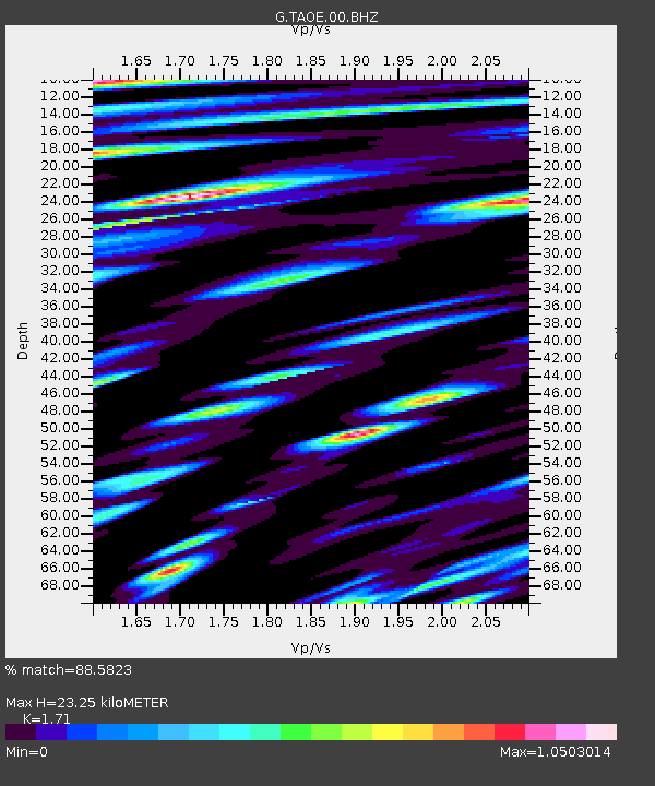
| Estimated Moho Depth: |
23.25 km |
| Estimated Crust Vp/Vs: |
1.71 |
| Assumed Crust Vp: |
4.24 km/s |
| Estimated Crust Vs: |
2.479 km/s |
| Estimated Crust Poisson's Ratio: |
0.24 |
|
| Radial Match: |
88.5823 % |
| Radial Bump: |
400 |
| Transverse Match: |
79.87555 % |
| Transverse Bump: |
400 |
| SOD ConfigId: |
18369291 |
| Insert Time: |
2019-06-09 07:46:10.252 +0000 |
| GWidth: |
2.5 |
| Max Bumps: |
400 |
| Tol: |
0.001 |
|
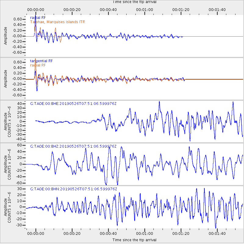
Signal To Noise
| Channel | StoN | STA | LTA |
| G:TAOE:00:BHZ:20190526T07:51:06.599976Z | 3.4252925 | 7.107759E-6 | 2.0750808E-6 |
| G:TAOE:00:BHN:20190526T07:51:06.599976Z | 0.9224202 | 1.3226347E-6 | 1.4338744E-6 |
| G:TAOE:00:BHE:20190526T07:51:06.599976Z | 2.2883124 | 3.287651E-6 | 1.4367142E-6 |
| Arrivals |
| Ps | 4.0 SECOND |
| PpPs | 15 SECOND |
| PsPs/PpSs | 19 SECOND |


