You are here: Home > Network List > GS - US Geological Survey Networks Stations List
> Station DEC05 Apollo Drive Surface Site > Earthquake Result Viewer
DEC05 Apollo Drive Surface Site - Earthquake Result Viewer
| Earthquake location: |
Northern Peru |
| Earthquake latitude/longitude: |
-5.9/-75.3 |
| Earthquake time(UTC): |
2019/05/26 (146) 07:41:13 GMT |
| Earthquake Depth: |
105 km |
| Earthquake Magnitude: |
7.5 Mi |
| Earthquake Catalog/Contributor: |
NEIC PDE/at |
|
| Network: |
GS US Geological Survey Networks |
| Station: |
DEC05 Apollo Drive Surface Site |
| Lat/Lon: |
39.87 N/88.87 W |
| Elevation: |
216 m |
|
| Distance: |
47.2 deg |
| Az: |
345.764 deg |
| Baz: |
161.466 deg |
| Ray Param: |
0.06977289 |
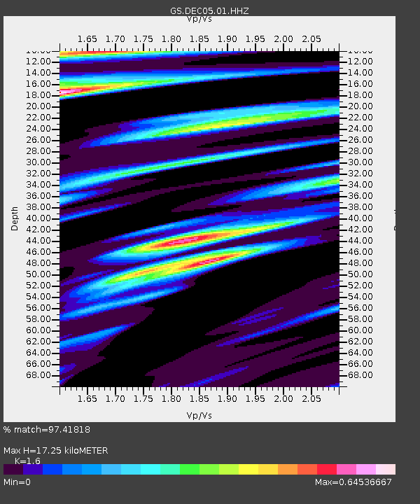
| Estimated Moho Depth: |
17.25 km |
| Estimated Crust Vp/Vs: |
1.60 |
| Assumed Crust Vp: |
6.444 km/s |
| Estimated Crust Vs: |
4.027 km/s |
| Estimated Crust Poisson's Ratio: |
0.18 |
|
| Radial Match: |
97.41818 % |
| Radial Bump: |
323 |
| Transverse Match: |
94.86136 % |
| Transverse Bump: |
400 |
| SOD ConfigId: |
18369291 |
| Insert Time: |
2019-06-09 07:46:34.887 +0000 |
| GWidth: |
2.5 |
| Max Bumps: |
400 |
| Tol: |
0.001 |
|
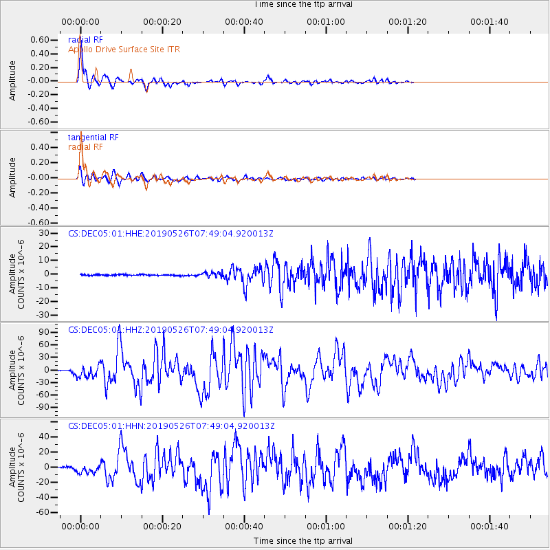
Signal To Noise
| Channel | StoN | STA | LTA |
| GS:DEC05:01:HHZ:20190526T07:49:04.920013Z | 23.733831 | 1.373503E-5 | 5.78711E-7 |
| GS:DEC05:01:HHN:20190526T07:49:04.920013Z | 9.573611 | 5.7482675E-6 | 6.0042834E-7 |
| GS:DEC05:01:HHE:20190526T07:49:04.920013Z | 4.8076706 | 1.6505995E-6 | 3.4332626E-7 |
| Arrivals |
| Ps | 1.7 SECOND |
| PpPs | 6.5 SECOND |
| PsPs/PpSs | 8.2 SECOND |


