You are here: Home > Network List > GS - US Geological Survey Networks Stations List
> Station KAN05 Bluff City North Station > Earthquake Result Viewer
KAN05 Bluff City North Station - Earthquake Result Viewer

| Earthquake location: |
Northern Peru |
| Earthquake latitude/longitude: |
-5.9/-75.3 |
| Earthquake time(UTC): |
2019/05/26 (146) 07:41:13 GMT |
| Earthquake Depth: |
105 km |
| Earthquake Magnitude: |
7.5 Mi |
| Earthquake Catalog/Contributor: |
NEIC PDE/at |
|
| Network: |
GS US Geological Survey Networks |
| Station: |
KAN05 Bluff City North Station |
| Lat/Lon: |
37.11 N/97.87 W |
| Elevation: |
348 m |
|
| Distance: |
47.7 deg |
| Az: |
335.488 deg |
| Baz: |
148.919 deg |
| Ray Param: |
0.06948297 |
| Estimated Moho Depth: |
40.25 km |
| Estimated Crust Vp/Vs: |
1.83 |
| Assumed Crust Vp: |
6.483 km/s |
| Estimated Crust Vs: |
3.547 km/s |
| Estimated Crust Poisson's Ratio: |
0.29 |
|
| Radial Match: |
98.50992 % |
| Radial Bump: |
270 |
| Transverse Match: |
89.01873 % |
| Transverse Bump: |
400 |
| SOD ConfigId: |
18369291 |
| Insert Time: |
2019-06-09 07:46:36.143 +0000 |
| GWidth: |
2.5 |
| Max Bumps: |
400 |
| Tol: |
0.001 |
|
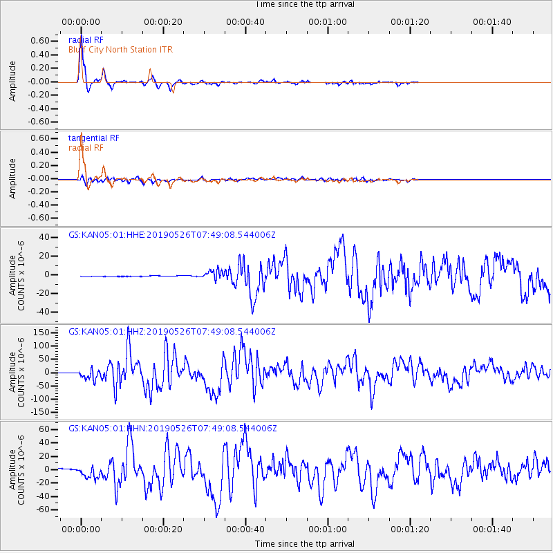
Signal To Noise
| Channel | StoN | STA | LTA |
| GS:KAN05:01:HHZ:20190526T07:49:08.544006Z | 37.319004 | 1.8950861E-5 | 5.078073E-7 |
| GS:KAN05:01:HHN:20190526T07:49:08.544006Z | 6.605977 | 8.731371E-6 | 1.3217381E-6 |
| GS:KAN05:01:HHE:20190526T07:49:08.544006Z | 11.224391 | 4.7676267E-6 | 4.2475594E-7 |
| Arrivals |
| Ps | 5.5 SECOND |
| PpPs | 17 SECOND |
| PsPs/PpSs | 22 SECOND |


