You are here: Home > Network List > GS - US Geological Survey Networks Stations List
> Station KAN08 Anthony NE Station > Earthquake Result Viewer
KAN08 Anthony NE Station - Earthquake Result Viewer
| Earthquake location: |
Northern Peru |
| Earthquake latitude/longitude: |
-5.9/-75.3 |
| Earthquake time(UTC): |
2019/05/26 (146) 07:41:13 GMT |
| Earthquake Depth: |
105 km |
| Earthquake Magnitude: |
7.5 Mi |
| Earthquake Catalog/Contributor: |
NEIC PDE/at |
|
| Network: |
GS US Geological Survey Networks |
| Station: |
KAN08 Anthony NE Station |
| Lat/Lon: |
37.23 N/97.97 W |
| Elevation: |
375 m |
|
| Distance: |
47.8 deg |
| Az: |
335.48 deg |
| Baz: |
148.854 deg |
| Ray Param: |
0.069395475 |
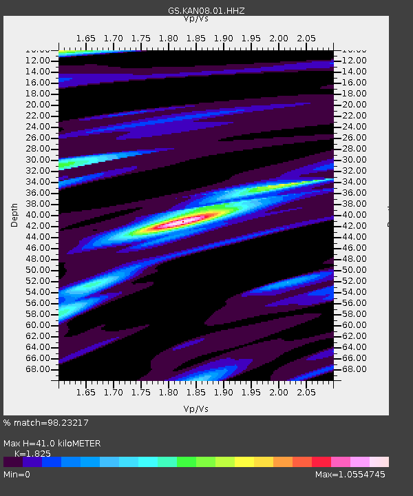
| Estimated Moho Depth: |
41.0 km |
| Estimated Crust Vp/Vs: |
1.83 |
| Assumed Crust Vp: |
6.483 km/s |
| Estimated Crust Vs: |
3.552 km/s |
| Estimated Crust Poisson's Ratio: |
0.29 |
|
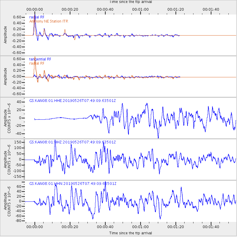
| Radial Match: |
98.23217 % |
| Radial Bump: |
260 |
| Transverse Match: |
88.31803 % |
| Transverse Bump: |
400 |
| SOD ConfigId: |
18369291 |
| Insert Time: |
2019-06-09 07:46:37.249 +0000 |
| GWidth: |
2.5 |
| Max Bumps: |
400 |
| Tol: |
0.001 |
|
Signal To Noise
| Channel | StoN | STA | LTA |
| GS:KAN08:01:HHZ:20190526T07:49:09.63501Z | 38.6837 | 1.9672201E-5 | 5.085398E-7 |
| GS:KAN08:01:HHN:20190526T07:49:09.63501Z | 5.4759946 | 7.4051054E-6 | 1.352285E-6 |
| GS:KAN08:01:HHE:20190526T07:49:09.63501Z | 3.4455764 | 5.6603103E-6 | 1.6427759E-6 |
| Arrivals |
| Ps | 5.5 SECOND |
| PpPs | 17 SECOND |
| PsPs/PpSs | 22 SECOND |


