You are here: Home > Network List > GS - US Geological Survey Networks Stations List
> Station KAN10 Keim Farm > Earthquake Result Viewer
KAN10 Keim Farm - Earthquake Result Viewer
| Earthquake location: |
Northern Peru |
| Earthquake latitude/longitude: |
-5.9/-75.3 |
| Earthquake time(UTC): |
2019/05/26 (146) 07:41:13 GMT |
| Earthquake Depth: |
105 km |
| Earthquake Magnitude: |
7.5 Mi |
| Earthquake Catalog/Contributor: |
NEIC PDE/at |
|
| Network: |
GS US Geological Survey Networks |
| Station: |
KAN10 Keim Farm |
| Lat/Lon: |
37.12 N/98.10 W |
| Elevation: |
417 m |
|
| Distance: |
47.8 deg |
| Az: |
335.293 deg |
| Baz: |
148.654 deg |
| Ray Param: |
0.06941811 |
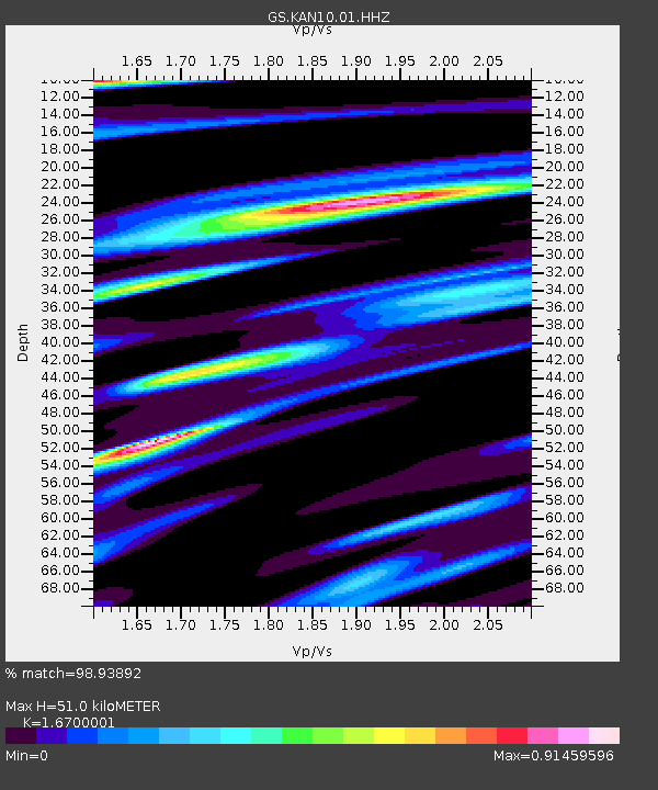
| Estimated Moho Depth: |
51.0 km |
| Estimated Crust Vp/Vs: |
1.67 |
| Assumed Crust Vp: |
6.426 km/s |
| Estimated Crust Vs: |
3.848 km/s |
| Estimated Crust Poisson's Ratio: |
0.22 |
|
| Radial Match: |
98.93892 % |
| Radial Bump: |
248 |
| Transverse Match: |
98.33806 % |
| Transverse Bump: |
280 |
| SOD ConfigId: |
18369291 |
| Insert Time: |
2019-06-09 07:46:37.510 +0000 |
| GWidth: |
2.5 |
| Max Bumps: |
400 |
| Tol: |
0.001 |
|
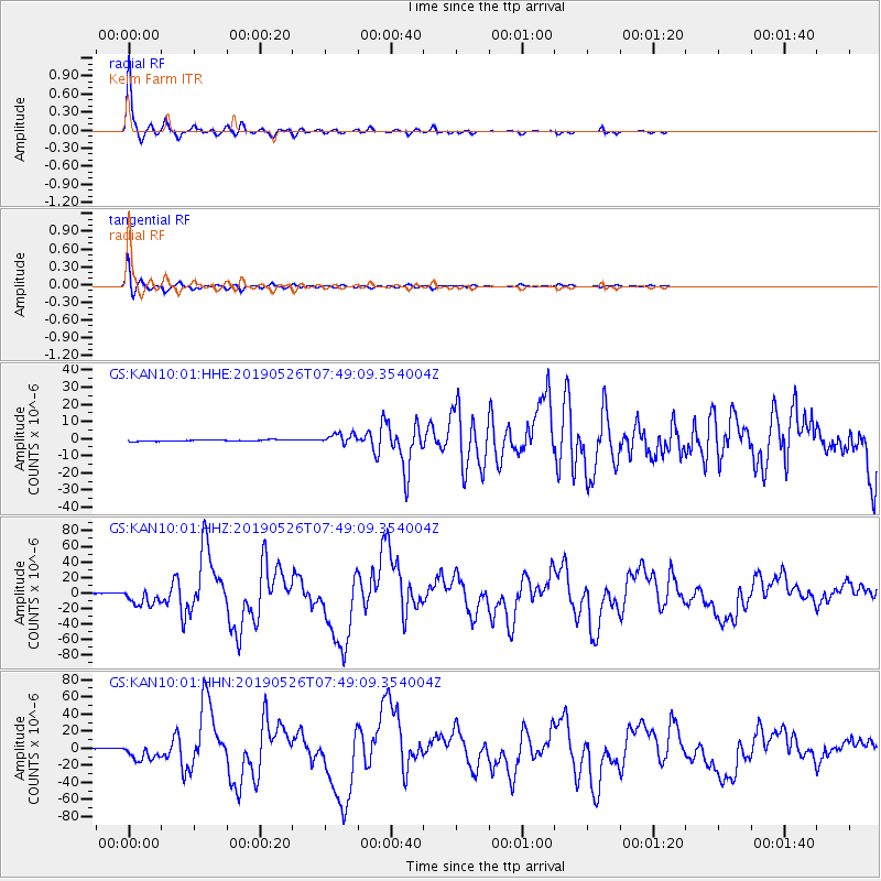
Signal To Noise
| Channel | StoN | STA | LTA |
| GS:KAN10:01:HHZ:20190526T07:49:09.354004Z | 10.846632 | 1.0292069E-5 | 9.488723E-7 |
| GS:KAN10:01:HHN:20190526T07:49:09.354004Z | 16.838055 | 9.314683E-6 | 5.5319236E-7 |
| GS:KAN10:01:HHE:20190526T07:49:09.354004Z | 7.4978666 | 3.0406334E-6 | 4.0553314E-7 |
| Arrivals |
| Ps | 5.7 SECOND |
| PpPs | 20 SECOND |
| PsPs/PpSs | 26 SECOND |


