You are here: Home > Network List > GS - US Geological Survey Networks Stations List
> Station OK032 Salt Plains WLR near Rte 11, Oklahoma, USA > Earthquake Result Viewer
OK032 Salt Plains WLR near Rte 11, Oklahoma, USA - Earthquake Result Viewer
| Earthquake location: |
Northern Peru |
| Earthquake latitude/longitude: |
-5.9/-75.3 |
| Earthquake time(UTC): |
2019/05/26 (146) 07:41:13 GMT |
| Earthquake Depth: |
105 km |
| Earthquake Magnitude: |
7.5 Mi |
| Earthquake Catalog/Contributor: |
NEIC PDE/at |
|
| Network: |
GS US Geological Survey Networks |
| Station: |
OK032 Salt Plains WLR near Rte 11, Oklahoma, USA |
| Lat/Lon: |
36.80 N/98.21 W |
| Elevation: |
345 m |
|
| Distance: |
47.6 deg |
| Az: |
334.961 deg |
| Baz: |
148.361 deg |
| Ray Param: |
0.06955639 |
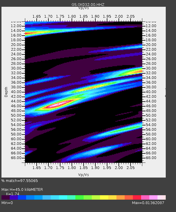
| Estimated Moho Depth: |
45.0 km |
| Estimated Crust Vp/Vs: |
1.74 |
| Assumed Crust Vp: |
6.426 km/s |
| Estimated Crust Vs: |
3.693 km/s |
| Estimated Crust Poisson's Ratio: |
0.25 |
|
| Radial Match: |
97.55065 % |
| Radial Bump: |
267 |
| Transverse Match: |
91.04973 % |
| Transverse Bump: |
400 |
| SOD ConfigId: |
18369291 |
| Insert Time: |
2019-06-09 07:46:41.311 +0000 |
| GWidth: |
2.5 |
| Max Bumps: |
400 |
| Tol: |
0.001 |
|

Signal To Noise
| Channel | StoN | STA | LTA |
| GS:OK032:00:HHZ:20190526T07:49:07.628998Z | 29.796715 | 1.593305E-5 | 5.347251E-7 |
| GS:OK032:00:HH1:20190526T07:49:07.628998Z | 11.139014 | 7.8260855E-6 | 7.0258335E-7 |
| GS:OK032:00:HH2:20190526T07:49:07.628998Z | 4.8889203 | 2.975245E-6 | 6.0856894E-7 |
| Arrivals |
| Ps | 5.5 SECOND |
| PpPs | 18 SECOND |
| PsPs/PpSs | 24 SECOND |


