You are here: Home > Network List > GS - US Geological Survey Networks Stations List
> Station OK052 Battle Ridge Rd, NW of Cushing, OK, USA > Earthquake Result Viewer
OK052 Battle Ridge Rd, NW of Cushing, OK, USA - Earthquake Result Viewer
| Earthquake location: |
Northern Peru |
| Earthquake latitude/longitude: |
-5.9/-75.3 |
| Earthquake time(UTC): |
2019/05/26 (146) 07:41:13 GMT |
| Earthquake Depth: |
105 km |
| Earthquake Magnitude: |
7.5 Mi |
| Earthquake Catalog/Contributor: |
NEIC PDE/at |
|
| Network: |
GS US Geological Survey Networks |
| Station: |
OK052 Battle Ridge Rd, NW of Cushing, OK, USA |
| Lat/Lon: |
35.99 N/96.80 W |
| Elevation: |
259 m |
|
| Distance: |
46.3 deg |
| Az: |
335.725 deg |
| Baz: |
149.714 deg |
| Ray Param: |
0.07037503 |
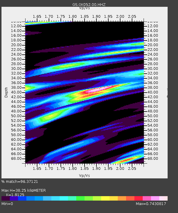
| Estimated Moho Depth: |
38.25 km |
| Estimated Crust Vp/Vs: |
1.91 |
| Assumed Crust Vp: |
6.426 km/s |
| Estimated Crust Vs: |
3.36 km/s |
| Estimated Crust Poisson's Ratio: |
0.31 |
|
| Radial Match: |
96.37121 % |
| Radial Bump: |
341 |
| Transverse Match: |
89.09272 % |
| Transverse Bump: |
400 |
| SOD ConfigId: |
18369291 |
| Insert Time: |
2019-06-09 07:46:42.368 +0000 |
| GWidth: |
2.5 |
| Max Bumps: |
400 |
| Tol: |
0.001 |
|

Signal To Noise
| Channel | StoN | STA | LTA |
| GS:OK052:00:HHZ:20190526T07:48:57.713989Z | 26.75197 | 1.581172E-5 | 5.910488E-7 |
| GS:OK052:00:HH1:20190526T07:48:57.713989Z | 39.60731 | 7.751792E-6 | 1.9571617E-7 |
| GS:OK052:00:HH2:20190526T07:48:57.713989Z | 23.964592 | 4.58702E-6 | 1.9140825E-7 |
| Arrivals |
| Ps | 5.8 SECOND |
| PpPs | 16 SECOND |
| PsPs/PpSs | 22 SECOND |


