You are here: Home > Network List > TS - TERRAscope (Southern California Seismic Network) Stations List
> Station GLA Glamis, California, USA > Earthquake Result Viewer
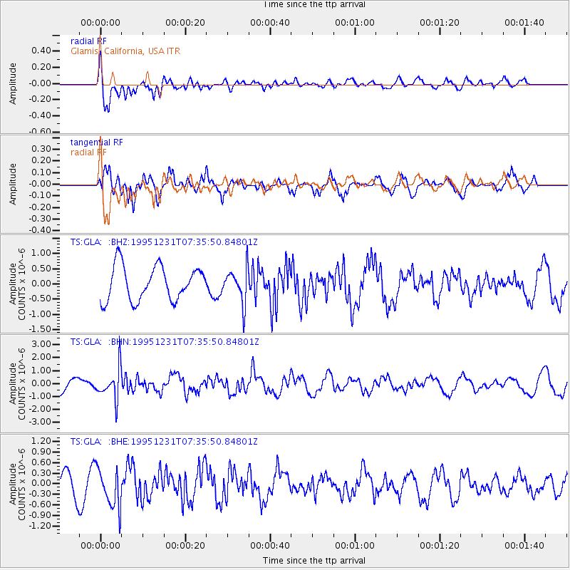
GLA Glamis, California, USA - Earthquake Result Viewer
*The percent match for this event was below the threshold and hence no stack was calculated.
| Earthquake location: |
Near East Coast Of Kamchatka |
| Earthquake latitude/longitude: |
53.9/160.6 |
| Earthquake time(UTC): |
1995/12/31 (365) 07:26:13 GMT |
| Earthquake Depth: |
55 km |
| Earthquake Magnitude: |
6.0 MB, 5.9 UNKNOWN, 5.7 MW |
| Earthquake Catalog/Contributor: |
WHDF/NEIC |
|
| Network: |
TS TERRAscope (Southern California Seismic Network) |
| Station: |
GLA Glamis, California, USA |
| Lat/Lon: |
33.05 N/114.83 W |
| Elevation: |
627 m |
|
| Distance: |
61.0 deg |
| Az: |
72.898 deg |
| Baz: |
317.636 deg |
| Ray Param: |
$rayparam |
*The percent match for this event was below the threshold and hence was not used in the summary stack. |
|
| Radial Match: |
63.925755 % |
| Radial Bump: |
400 |
| Transverse Match: |
72.49424 % |
| Transverse Bump: |
400 |
| SOD ConfigId: |
4480 |
| Insert Time: |
2010-02-26 14:14:15.941 +0000 |
| GWidth: |
2.5 |
| Max Bumps: |
400 |
| Tol: |
0.001 |
|
Signal To Noise
| Channel | StoN | STA | LTA |
| TS:GLA: :BHN:19951231T07:35:50.84801Z | 1.8136101 | 1.2462723E-6 | 6.871777E-7 |
| TS:GLA: :BHE:19951231T07:35:50.84801Z | 1.886201 | 5.42643E-7 | 2.87691E-7 |
| TS:GLA: :BHZ:19951231T07:35:50.84801Z | 1.0325363 | 5.7673753E-7 | 5.5856395E-7 |
| Arrivals |
| Ps | |
| PpPs | |
| PsPs/PpSs | |


