You are here: Home > Network List > LM - Michigan State University Seismic Network Stations List
> Station L48A N Adams, MI, USA > Earthquake Result Viewer
L48A N Adams, MI, USA - Earthquake Result Viewer
| Earthquake location: |
Northern Peru |
| Earthquake latitude/longitude: |
-5.9/-75.3 |
| Earthquake time(UTC): |
2019/05/26 (146) 07:41:13 GMT |
| Earthquake Depth: |
105 km |
| Earthquake Magnitude: |
7.5 Mi |
| Earthquake Catalog/Contributor: |
NEIC PDE/at |
|
| Network: |
LM Michigan State University Seismic Network |
| Station: |
L48A N Adams, MI, USA |
| Lat/Lon: |
41.94 N/84.43 W |
| Elevation: |
369 m |
|
| Distance: |
48.3 deg |
| Az: |
350.88 deg |
| Baz: |
167.799 deg |
| Ray Param: |
0.0690672 |
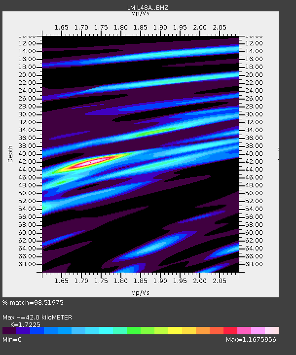
| Estimated Moho Depth: |
42.0 km |
| Estimated Crust Vp/Vs: |
1.72 |
| Assumed Crust Vp: |
6.498 km/s |
| Estimated Crust Vs: |
3.772 km/s |
| Estimated Crust Poisson's Ratio: |
0.25 |
|
| Radial Match: |
98.51975 % |
| Radial Bump: |
277 |
| Transverse Match: |
91.816956 % |
| Transverse Bump: |
400 |
| SOD ConfigId: |
18369291 |
| Insert Time: |
2019-06-09 07:47:39.614 +0000 |
| GWidth: |
2.5 |
| Max Bumps: |
400 |
| Tol: |
0.001 |
|

Signal To Noise
| Channel | StoN | STA | LTA |
| LM:L48A: :BHZ:20190526T07:49:13.450012Z | 22.53136 | 1.1302204E-5 | 5.01621E-7 |
| LM:L48A: :BHN:20190526T07:49:13.450012Z | 16.433334 | 6.2713316E-6 | 3.816226E-7 |
| LM:L48A: :BHE:20190526T07:49:13.450012Z | 6.237273 | 1.0391877E-6 | 1.666093E-7 |
| Arrivals |
| Ps | 5.0 SECOND |
| PpPs | 17 SECOND |
| PsPs/PpSs | 21 SECOND |


