You are here: Home > Network List > TA - USArray Transportable Network (new EarthScope stations) Stations List
> Station Y13A Salome, AZ, USA > Earthquake Result Viewer
Y13A Salome, AZ, USA - Earthquake Result Viewer
| Earthquake location: |
Windward Islands |
| Earthquake latitude/longitude: |
15.0/-61.3 |
| Earthquake time(UTC): |
2007/11/29 (333) 19:00:19 GMT |
| Earthquake Depth: |
148 km |
| Earthquake Magnitude: |
6.9 MB, 7.4 MW, 7.4 MW |
| Earthquake Catalog/Contributor: |
WHDF/NEIC |
|
| Network: |
TA USArray Transportable Network (new EarthScope stations) |
| Station: |
Y13A Salome, AZ, USA |
| Lat/Lon: |
33.81 N/113.83 W |
| Elevation: |
357 m |
|
| Distance: |
50.9 deg |
| Az: |
301.519 deg |
| Baz: |
98.278 deg |
| Ray Param: |
0.06728757 |
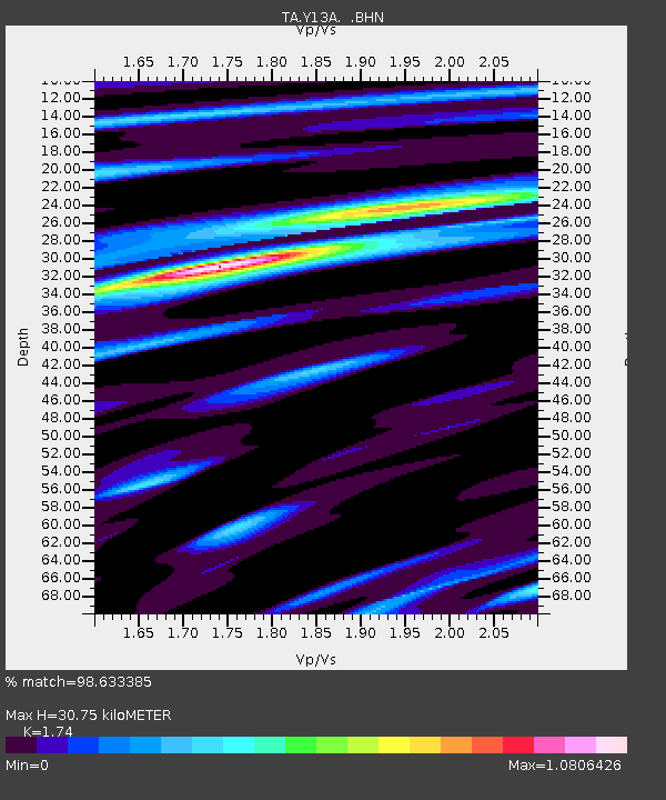
| Estimated Moho Depth: |
30.75 km |
| Estimated Crust Vp/Vs: |
1.74 |
| Assumed Crust Vp: |
6.264 km/s |
| Estimated Crust Vs: |
3.6 km/s |
| Estimated Crust Poisson's Ratio: |
0.25 |
|
| Radial Match: |
98.633385 % |
| Radial Bump: |
346 |
| Transverse Match: |
90.7661 % |
| Transverse Bump: |
400 |
| SOD ConfigId: |
2564 |
| Insert Time: |
2010-03-06 22:57:38.153 +0000 |
| GWidth: |
2.5 |
| Max Bumps: |
400 |
| Tol: |
0.001 |
|
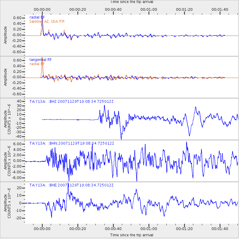
Signal To Noise
| Channel | StoN | STA | LTA |
| TA:Y13A: :BHN:20071129T19:08:34.725012Z | 12.136415 | 9.5300936E-7 | 7.8524785E-8 |
| TA:Y13A: :BHE:20071129T19:08:34.725012Z | 19.738691 | 3.9109136E-6 | 1.981344E-7 |
| TA:Y13A: :BHZ:20071129T19:08:34.725012Z | 33.32618 | 8.37513E-6 | 2.5130785E-7 |
| Arrivals |
| Ps | 3.8 SECOND |
| PpPs | 13 SECOND |
| PsPs/PpSs | 17 SECOND |


