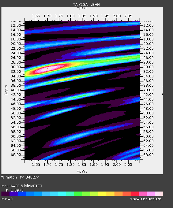
Y13A Salome, AZ, USA - Earthquake Result Viewer

Earthquake location: Andreanof Islands, Aleutian Is.
Earthquake latitude/longitude: 51.4/-179.5
Earthquake time(UTC): 2007/12/19 (353) 09:30:27 GMT
Earthquake Depth: 29 km
Earthquake Magnitude: 6.4 MB, 7.1 MS, 7.1 MW, 7.0 MW
Earthquake Catalog/Contributor: WHDF/NEIC
Network: TA USArray Transportable Network (new EarthScope stations)
Station: Y13A Salome, AZ, USA
Lat/Lon: 33.81 N/113.83 W
Elevation: 357 m
Distance: 49.7 deg
Az: 83.96 deg
Baz: 311.51 deg
Ray Param: 0.068463236
Estimated Moho Depth: 30.5 km
Estimated Crust Vp/Vs: 1.70
Assumed Crust Vp: 6.264 km/s
Estimated Crust Vs: 3.69 km/s
Estimated Crust Poisson's Ratio: 0.23
Radial Match: 94.348274 %
Radial Bump: 345
Transverse Match: 69.893845 %
Transverse Bump: 400
SOD ConfigId: 2564
Insert Time: 2010-03-06 22:57:40.360 +0000
GWidth: 2.5
Max Bumps: 400
Tol: 0.001

Signal To Noise

ChannelStoNSTALTA
TA:Y13A: :BHN:20071219T09:38:46.075002Z4.2242538.1990834E-71.9409546E-7
TA:Y13A: :BHE:20071219T09:38:46.075002Z2.67941887.957427E-72.9698333E-7
TA:Y13A: :BHZ:20071219T09:38:46.075002Z3.55783531.8287102E-65.139952E-7
Arrivals
Ps3.6 SECOND
PpPs12 SECOND
PsPs/PpSs16 SECOND