You are here: Home > Network List > TA - USArray Transportable Network (new EarthScope stations) Stations List
> Station Y13A Salome, AZ, USA > Earthquake Result Viewer
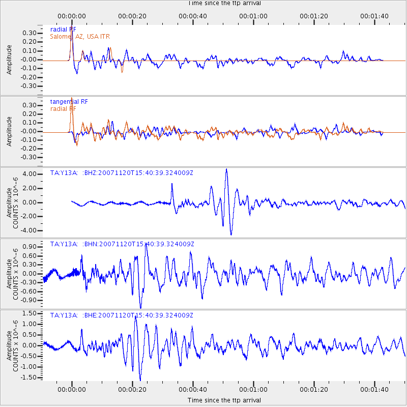
Y13A Salome, AZ, USA - Earthquake Result Viewer
| Earthquake location: |
Kermadec Islands, New Zealand |
| Earthquake latitude/longitude: |
-30.0/-177.9 |
| Earthquake time(UTC): |
2007/11/20 (324) 15:28:28 GMT |
| Earthquake Depth: |
59 km |
| Earthquake Magnitude: |
6.0 MB, 5.9 MW, 5.8 MW |
| Earthquake Catalog/Contributor: |
WHDF/NEIC |
|
| Network: |
TA USArray Transportable Network (new EarthScope stations) |
| Station: |
Y13A Salome, AZ, USA |
| Lat/Lon: |
33.81 N/113.83 W |
| Elevation: |
357 m |
|
| Distance: |
87.7 deg |
| Az: |
48.549 deg |
| Baz: |
231.324 deg |
| Ray Param: |
0.04300336 |
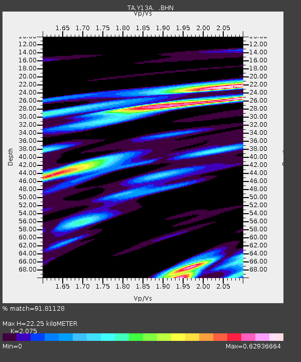
| Estimated Moho Depth: |
22.25 km |
| Estimated Crust Vp/Vs: |
2.08 |
| Assumed Crust Vp: |
6.264 km/s |
| Estimated Crust Vs: |
3.019 km/s |
| Estimated Crust Poisson's Ratio: |
0.35 |
|
| Radial Match: |
91.81128 % |
| Radial Bump: |
400 |
| Transverse Match: |
84.937294 % |
| Transverse Bump: |
400 |
| SOD ConfigId: |
2564 |
| Insert Time: |
2010-03-06 22:57:45.328 +0000 |
| GWidth: |
2.5 |
| Max Bumps: |
400 |
| Tol: |
0.001 |
|
Signal To Noise
| Channel | StoN | STA | LTA |
| TA:Y13A: :BHN:20071120T15:40:39.324009Z | 2.100722 | 1.9816966E-7 | 9.433407E-8 |
| TA:Y13A: :BHE:20071120T15:40:39.324009Z | 2.4891548 | 2.670132E-7 | 1.0727064E-7 |
| TA:Y13A: :BHZ:20071120T15:40:39.324009Z | 4.8736935 | 8.304612E-7 | 1.7039669E-7 |
| Arrivals |
| Ps | 3.9 SECOND |
| PpPs | 11 SECOND |
| PsPs/PpSs | 15 SECOND |


