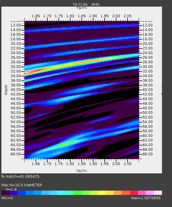
Y13A Salome, AZ, USA - Earthquake Result Viewer
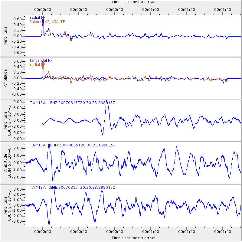
Earthquake location: Andreanof Islands, Aleutian Is.
Earthquake latitude/longitude: 50.3/-177.5
Earthquake time(UTC): 2007/08/15 (227) 20:22:11 GMT
Earthquake Depth: 9.0 km
Earthquake Magnitude: 6.3 MB, 6.2 MS, 6.4 MW, 5.9 ML
Earthquake Catalog/Contributor: WHDF/NEIC
Network: TA USArray Transportable Network (new EarthScope stations)
Station: Y13A Salome, AZ, USA
Lat/Lon: 33.81 N/113.83 W
Elevation: 357 m
Distance: 48.6 deg
Az: 84.481 deg
Baz: 309.973 deg
Ray Param: 0.069263764
Estimated Moho Depth: 32.5 km
Estimated Crust Vp/Vs: 1.60
Assumed Crust Vp: 6.264 km/s
Estimated Crust Vs: 3.915 km/s
Estimated Crust Poisson's Ratio: 0.18
Radial Match: 81.865425 %
Radial Bump: 400
Transverse Match: 56.78545 %
Transverse Bump: 400
SOD ConfigId: 2564
Insert Time: 2010-03-06 22:58:20.731 +0000
GWidth: 2.5
Max Bumps: 400
Tol: 0.001

Signal To Noise

ChannelStoNSTALTA
TA:Y13A: :BHN:20070815T20:30:23.898015Z1.54524681.3470782E-68.71756E-7
TA:Y13A: :BHE:20070815T20:30:23.898015Z2.4899261.5909277E-66.389458E-7
TA:Y13A: :BHZ:20070815T20:30:23.898015Z3.94585283.0166175E-67.6450334E-7
Arrivals
Ps3.3 SECOND
PpPs13 SECOND
PsPs/PpSs16 SECOND