You are here: Home > Network List > N4 - Central and EAstern US Network Stations List
> Station W57A Gilead, NC, USA > Earthquake Result Viewer
W57A Gilead, NC, USA - Earthquake Result Viewer
| Earthquake location: |
Northern Peru |
| Earthquake latitude/longitude: |
-5.9/-75.3 |
| Earthquake time(UTC): |
2019/05/26 (146) 07:41:13 GMT |
| Earthquake Depth: |
105 km |
| Earthquake Magnitude: |
7.5 Mi |
| Earthquake Catalog/Contributor: |
NEIC PDE/at |
|
| Network: |
N4 Central and EAstern US Network |
| Station: |
W57A Gilead, NC, USA |
| Lat/Lon: |
35.15 N/79.99 W |
| Elevation: |
85 m |
|
| Distance: |
41.1 deg |
| Az: |
354.143 deg |
| Baz: |
172.884 deg |
| Ray Param: |
0.073649205 |
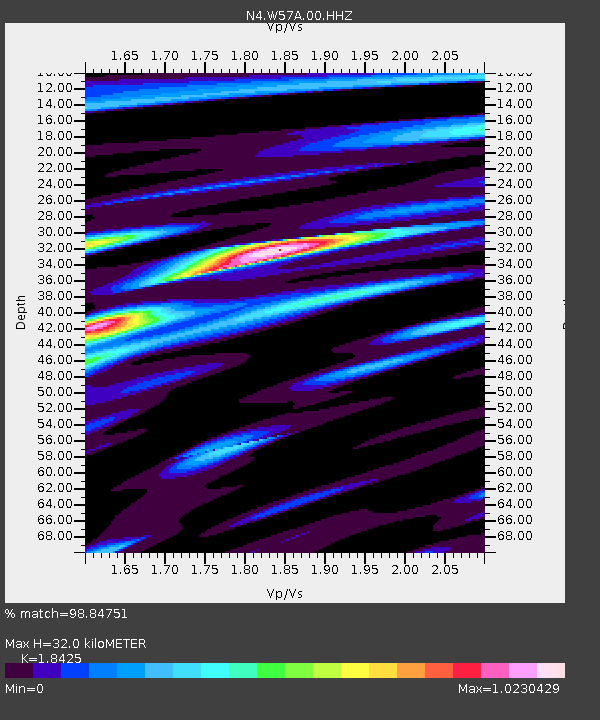
| Estimated Moho Depth: |
32.0 km |
| Estimated Crust Vp/Vs: |
1.84 |
| Assumed Crust Vp: |
6.565 km/s |
| Estimated Crust Vs: |
3.563 km/s |
| Estimated Crust Poisson's Ratio: |
0.29 |
|
| Radial Match: |
98.84751 % |
| Radial Bump: |
281 |
| Transverse Match: |
92.4741 % |
| Transverse Bump: |
400 |
| SOD ConfigId: |
18369291 |
| Insert Time: |
2019-06-09 07:48:48.442 +0000 |
| GWidth: |
2.5 |
| Max Bumps: |
400 |
| Tol: |
0.001 |
|

Signal To Noise
| Channel | StoN | STA | LTA |
| N4:W57A:00:HHZ:20190526T07:48:15.878998Z | 12.496303 | 1.2061364E-5 | 9.651947E-7 |
| N4:W57A:00:HH1:20190526T07:48:15.878998Z | 9.50119 | 7.079029E-6 | 7.450676E-7 |
| N4:W57A:00:HH2:20190526T07:48:15.878998Z | 10.4665785 | 1.4287605E-6 | 1.3650693E-7 |
| Arrivals |
| Ps | 4.4 SECOND |
| PpPs | 13 SECOND |
| PsPs/PpSs | 17 SECOND |


