You are here: Home > Network List > TA - USArray Transportable Network (new EarthScope stations) Stations List
> Station Y13A Salome, AZ, USA > Earthquake Result Viewer
Y13A Salome, AZ, USA - Earthquake Result Viewer
| Earthquake location: |
Kamchatka Peninsula, Russia |
| Earthquake latitude/longitude: |
52.1/157.3 |
| Earthquake time(UTC): |
2007/05/30 (150) 20:22:12 GMT |
| Earthquake Depth: |
116 km |
| Earthquake Magnitude: |
6.4 MB, 6.4 MW, 6.4 MW |
| Earthquake Catalog/Contributor: |
WHDF/NEIC |
|
| Network: |
TA USArray Transportable Network (new EarthScope stations) |
| Station: |
Y13A Salome, AZ, USA |
| Lat/Lon: |
33.81 N/113.83 W |
| Elevation: |
357 m |
|
| Distance: |
63.5 deg |
| Az: |
68.46 deg |
| Baz: |
316.481 deg |
| Ray Param: |
0.059213363 |
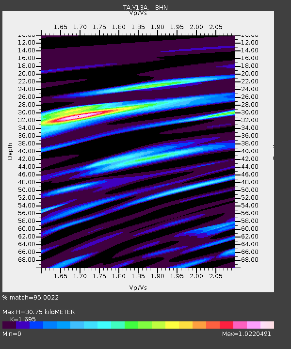
| Estimated Moho Depth: |
30.75 km |
| Estimated Crust Vp/Vs: |
1.70 |
| Assumed Crust Vp: |
6.264 km/s |
| Estimated Crust Vs: |
3.695 km/s |
| Estimated Crust Poisson's Ratio: |
0.23 |
|
| Radial Match: |
95.0022 % |
| Radial Bump: |
400 |
| Transverse Match: |
85.967 % |
| Transverse Bump: |
400 |
| SOD ConfigId: |
2564 |
| Insert Time: |
2010-03-06 22:58:42.655 +0000 |
| GWidth: |
2.5 |
| Max Bumps: |
400 |
| Tol: |
0.001 |
|

Signal To Noise
| Channel | StoN | STA | LTA |
| TA:Y13A: :BHN:20070530T20:31:59.725002Z | 19.481056 | 1.493463E-6 | 7.6662324E-8 |
| TA:Y13A: :BHE:20070530T20:31:59.725002Z | 20.262579 | 1.5264773E-6 | 7.5334796E-8 |
| TA:Y13A: :BHZ:20070530T20:31:59.725002Z | 56.186634 | 4.0795126E-6 | 7.260646E-8 |
| Arrivals |
| Ps | 3.6 SECOND |
| PpPs | 13 SECOND |
| PsPs/PpSs | 16 SECOND |


