You are here: Home > Network List > TA - USArray Transportable Network (new EarthScope stations) Stations List
> Station Y13A Salome, AZ, USA > Earthquake Result Viewer
Y13A Salome, AZ, USA - Earthquake Result Viewer

| Earthquake location: |
Kuril Islands |
| Earthquake latitude/longitude: |
47.1/154.4 |
| Earthquake time(UTC): |
2006/11/15 (319) 12:16:05 GMT |
| Earthquake Depth: |
10 km |
| Earthquake Magnitude: |
5.7 MB |
| Earthquake Catalog/Contributor: |
WHDF/NEIC |
|
| Network: |
TA USArray Transportable Network (new EarthScope stations) |
| Station: |
Y13A Salome, AZ, USA |
| Lat/Lon: |
33.81 N/113.83 W |
| Elevation: |
357 m |
|
| Distance: |
67.2 deg |
| Az: |
64.498 deg |
| Baz: |
312.229 deg |
| Ray Param: |
0.057097554 |
| Estimated Moho Depth: |
41.0 km |
| Estimated Crust Vp/Vs: |
1.92 |
| Assumed Crust Vp: |
6.264 km/s |
| Estimated Crust Vs: |
3.258 km/s |
| Estimated Crust Poisson's Ratio: |
0.31 |
|
| Radial Match: |
84.872444 % |
| Radial Bump: |
400 |
| Transverse Match: |
93.98777 % |
| Transverse Bump: |
400 |
| SOD ConfigId: |
2564 |
| Insert Time: |
2010-03-06 22:58:48.270 +0000 |
| GWidth: |
2.5 |
| Max Bumps: |
400 |
| Tol: |
0.001 |
|
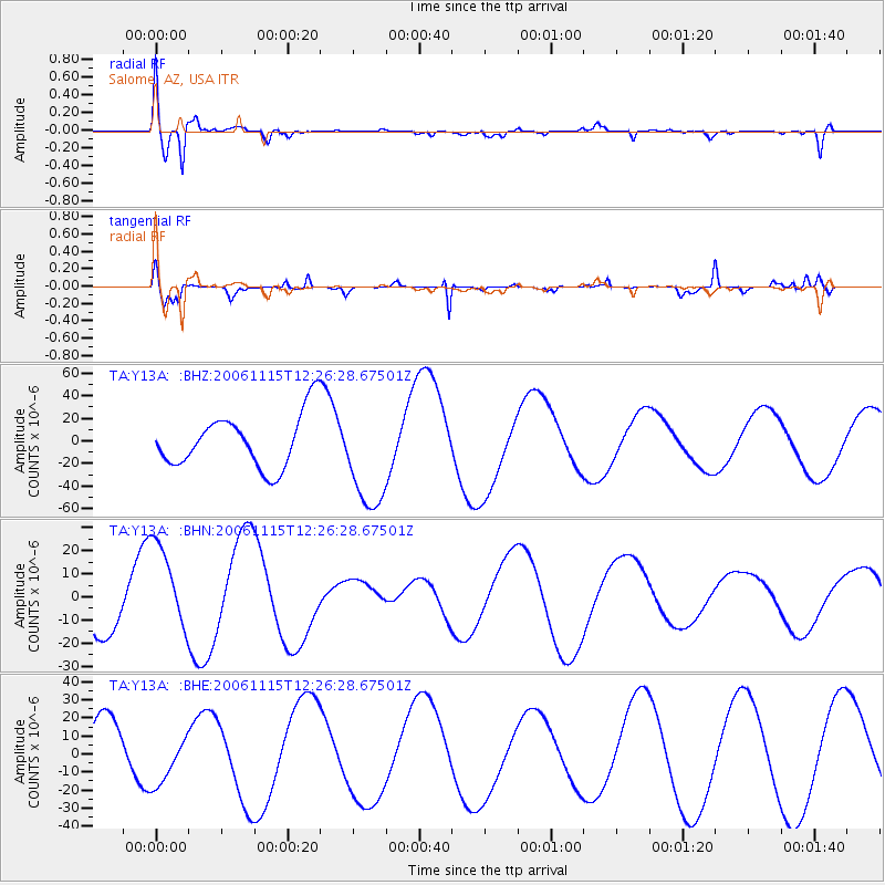
Signal To Noise
| Channel | StoN | STA | LTA |
| TA:Y13A: :BHN:20061115T12:26:28.67501Z | 1.1415279 | 1.897374E-5 | 1.6621354E-5 |
| TA:Y13A: :BHE:20061115T12:26:28.67501Z | 0.96033496 | 1.3722216E-5 | 1.4288989E-5 |
| TA:Y13A: :BHZ:20061115T12:26:28.67501Z | 1.9934494 | 4.707847E-5 | 2.3616585E-5 |
| Arrivals |
| Ps | 6.3 SECOND |
| PpPs | 18 SECOND |
| PsPs/PpSs | 25 SECOND |


