You are here: Home > Network List > O2 - Oklahoma Consolidated Temporary Seismic Networks Stations List
> Station SC11 Cordell, Oklahoma, USA > Earthquake Result Viewer
SC11 Cordell, Oklahoma, USA - Earthquake Result Viewer
| Earthquake location: |
Northern Peru |
| Earthquake latitude/longitude: |
-5.9/-75.3 |
| Earthquake time(UTC): |
2019/05/26 (146) 07:41:13 GMT |
| Earthquake Depth: |
105 km |
| Earthquake Magnitude: |
7.5 Mi |
| Earthquake Catalog/Contributor: |
NEIC PDE/at |
|
| Network: |
O2 Oklahoma Consolidated Temporary Seismic Networks |
| Station: |
SC11 Cordell, Oklahoma, USA |
| Lat/Lon: |
35.18 N/98.74 W |
| Elevation: |
419 m |
|
| Distance: |
46.4 deg |
| Az: |
333.281 deg |
| Baz: |
146.905 deg |
| Ray Param: |
0.07028161 |
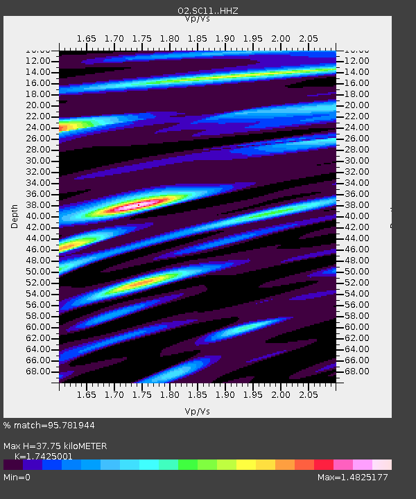
| Estimated Moho Depth: |
37.75 km |
| Estimated Crust Vp/Vs: |
1.74 |
| Assumed Crust Vp: |
6.315 km/s |
| Estimated Crust Vs: |
3.624 km/s |
| Estimated Crust Poisson's Ratio: |
0.25 |
|
| Radial Match: |
95.781944 % |
| Radial Bump: |
392 |
| Transverse Match: |
91.213326 % |
| Transverse Bump: |
400 |
| SOD ConfigId: |
18369291 |
| Insert Time: |
2019-06-09 07:49:49.418 +0000 |
| GWidth: |
2.5 |
| Max Bumps: |
400 |
| Tol: |
0.001 |
|

Signal To Noise
| Channel | StoN | STA | LTA |
| O2:SC11: :HHZ:20190526T07:48:58.815002Z | 26.545198 | 1.6593327E-5 | 6.2509713E-7 |
| O2:SC11: :HHN:20190526T07:48:58.815002Z | 11.982303 | 5.2108126E-6 | 4.3487572E-7 |
| O2:SC11: :HHE:20190526T07:48:58.815002Z | 8.367009 | 3.5169091E-6 | 4.203305E-7 |
| Arrivals |
| Ps | 4.7 SECOND |
| PpPs | 15 SECOND |
| PsPs/PpSs | 20 SECOND |


