You are here: Home > Network List > O2 - Oklahoma Consolidated Temporary Seismic Networks Stations List
> Station SC12 Granite, Oklahoma, USA > Earthquake Result Viewer
SC12 Granite, Oklahoma, USA - Earthquake Result Viewer
| Earthquake location: |
Northern Peru |
| Earthquake latitude/longitude: |
-5.9/-75.3 |
| Earthquake time(UTC): |
2019/05/26 (146) 07:41:13 GMT |
| Earthquake Depth: |
105 km |
| Earthquake Magnitude: |
7.5 Mi |
| Earthquake Catalog/Contributor: |
NEIC PDE/at |
|
| Network: |
O2 Oklahoma Consolidated Temporary Seismic Networks |
| Station: |
SC12 Granite, Oklahoma, USA |
| Lat/Lon: |
34.92 N/99.35 W |
| Elevation: |
472 m |
|
| Distance: |
46.5 deg |
| Az: |
332.503 deg |
| Baz: |
146.019 deg |
| Ray Param: |
0.07024106 |
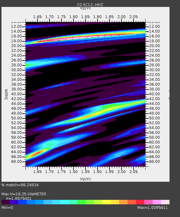
| Estimated Moho Depth: |
16.25 km |
| Estimated Crust Vp/Vs: |
1.86 |
| Assumed Crust Vp: |
6.315 km/s |
| Estimated Crust Vs: |
3.4 km/s |
| Estimated Crust Poisson's Ratio: |
0.30 |
|
| Radial Match: |
98.24834 % |
| Radial Bump: |
297 |
| Transverse Match: |
90.02868 % |
| Transverse Bump: |
400 |
| SOD ConfigId: |
18369291 |
| Insert Time: |
2019-06-09 07:49:50.718 +0000 |
| GWidth: |
2.5 |
| Max Bumps: |
400 |
| Tol: |
0.001 |
|

Signal To Noise
| Channel | StoN | STA | LTA |
| O2:SC12: :HHZ:20190526T07:48:59.295013Z | 23.063068 | 1.2530501E-5 | 5.4331457E-7 |
| O2:SC12: :HHN:20190526T07:48:59.295013Z | 12.988135 | 5.866501E-6 | 4.5168153E-7 |
| O2:SC12: :HHE:20190526T07:48:59.295013Z | 13.913941 | 4.360664E-6 | 3.134025E-7 |
| Arrivals |
| Ps | 2.3 SECOND |
| PpPs | 6.9 SECOND |
| PsPs/PpSs | 9.3 SECOND |


