You are here: Home > Network List > O2 - Oklahoma Consolidated Temporary Seismic Networks Stations List
> Station SC15 Hammon, Oklahoma, USA > Earthquake Result Viewer
SC15 Hammon, Oklahoma, USA - Earthquake Result Viewer
| Earthquake location: |
Northern Peru |
| Earthquake latitude/longitude: |
-5.9/-75.3 |
| Earthquake time(UTC): |
2019/05/26 (146) 07:41:13 GMT |
| Earthquake Depth: |
105 km |
| Earthquake Magnitude: |
7.5 Mi |
| Earthquake Catalog/Contributor: |
NEIC PDE/at |
|
| Network: |
O2 Oklahoma Consolidated Temporary Seismic Networks |
| Station: |
SC15 Hammon, Oklahoma, USA |
| Lat/Lon: |
35.61 N/99.50 W |
| Elevation: |
550 m |
|
| Distance: |
47.1 deg |
| Az: |
332.89 deg |
| Baz: |
146.199 deg |
| Ray Param: |
0.0698289 |
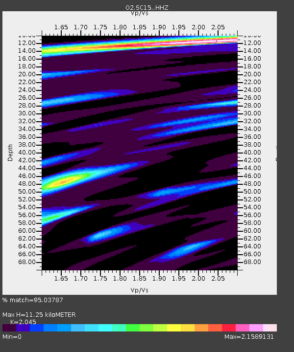
| Estimated Moho Depth: |
11.25 km |
| Estimated Crust Vp/Vs: |
2.05 |
| Assumed Crust Vp: |
6.315 km/s |
| Estimated Crust Vs: |
3.088 km/s |
| Estimated Crust Poisson's Ratio: |
0.34 |
|
| Radial Match: |
95.03787 % |
| Radial Bump: |
400 |
| Transverse Match: |
84.57129 % |
| Transverse Bump: |
400 |
| SOD ConfigId: |
18369291 |
| Insert Time: |
2019-06-09 07:49:52.076 +0000 |
| GWidth: |
2.5 |
| Max Bumps: |
400 |
| Tol: |
0.001 |
|

Signal To Noise
| Channel | StoN | STA | LTA |
| O2:SC15: :HHZ:20190526T07:49:04.220001Z | 26.407799 | 2.5284948E-5 | 9.574803E-7 |
| O2:SC15: :HHN:20190526T07:49:04.220001Z | 12.371199 | 8.144956E-6 | 6.583805E-7 |
| O2:SC15: :HHE:20190526T07:49:04.220001Z | 8.676313 | 6.5445606E-6 | 7.5430205E-7 |
| Arrivals |
| Ps | 2.0 SECOND |
| PpPs | 5.2 SECOND |
| PsPs/PpSs | 7.1 SECOND |


