You are here: Home > Network List > O2 - Oklahoma Consolidated Temporary Seismic Networks Stations List
> Station SC18 Garber, Oklahoma, USA > Earthquake Result Viewer
SC18 Garber, Oklahoma, USA - Earthquake Result Viewer
| Earthquake location: |
Northern Peru |
| Earthquake latitude/longitude: |
-5.9/-75.3 |
| Earthquake time(UTC): |
2019/05/26 (146) 07:41:13 GMT |
| Earthquake Depth: |
105 km |
| Earthquake Magnitude: |
7.5 Mi |
| Earthquake Catalog/Contributor: |
NEIC PDE/at |
|
| Network: |
O2 Oklahoma Consolidated Temporary Seismic Networks |
| Station: |
SC18 Garber, Oklahoma, USA |
| Lat/Lon: |
36.50 N/97.55 W |
| Elevation: |
1051 m |
|
| Distance: |
47.1 deg |
| Az: |
335.362 deg |
| Baz: |
149.023 deg |
| Ray Param: |
0.06988444 |
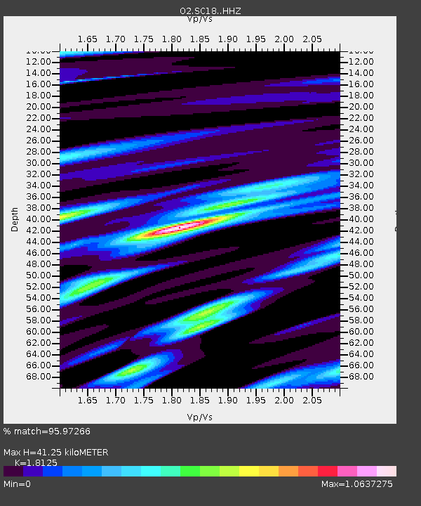
| Estimated Moho Depth: |
41.25 km |
| Estimated Crust Vp/Vs: |
1.81 |
| Assumed Crust Vp: |
6.483 km/s |
| Estimated Crust Vs: |
3.577 km/s |
| Estimated Crust Poisson's Ratio: |
0.28 |
|
| Radial Match: |
95.97266 % |
| Radial Bump: |
302 |
| Transverse Match: |
88.46978 % |
| Transverse Bump: |
400 |
| SOD ConfigId: |
18369291 |
| Insert Time: |
2019-06-09 07:49:52.690 +0000 |
| GWidth: |
2.5 |
| Max Bumps: |
400 |
| Tol: |
0.001 |
|

Signal To Noise
| Channel | StoN | STA | LTA |
| O2:SC18: :HHZ:20190526T07:49:03.519989Z | 32.910732 | 1.773849E-5 | 5.38988E-7 |
| O2:SC18: :HHN:20190526T07:49:03.519989Z | 10.343522 | 6.82525E-6 | 6.598574E-7 |
| O2:SC18: :HHE:20190526T07:49:03.519989Z | 16.59099 | 3.7259765E-6 | 2.2457832E-7 |
| Arrivals |
| Ps | 5.5 SECOND |
| PpPs | 17 SECOND |
| PsPs/PpSs | 22 SECOND |


