You are here: Home > Network List > O2 - Oklahoma Consolidated Temporary Seismic Networks Stations List
> Station SMNL Seminole, Oklahoma, USA > Earthquake Result Viewer
SMNL Seminole, Oklahoma, USA - Earthquake Result Viewer
| Earthquake location: |
Northern Peru |
| Earthquake latitude/longitude: |
-5.9/-75.3 |
| Earthquake time(UTC): |
2019/05/26 (146) 07:41:13 GMT |
| Earthquake Depth: |
105 km |
| Earthquake Magnitude: |
7.5 Mi |
| Earthquake Catalog/Contributor: |
NEIC PDE/at |
|
| Network: |
O2 Oklahoma Consolidated Temporary Seismic Networks |
| Station: |
SMNL Seminole, Oklahoma, USA |
| Lat/Lon: |
35.29 N/96.56 W |
| Elevation: |
317 m |
|
| Distance: |
45.6 deg |
| Az: |
335.467 deg |
| Baz: |
149.673 deg |
| Ray Param: |
0.07081376 |
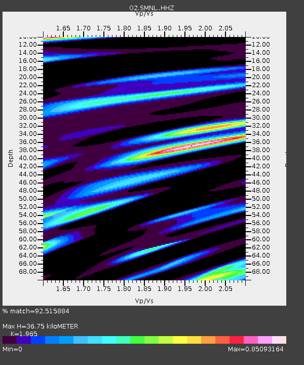
| Estimated Moho Depth: |
36.75 km |
| Estimated Crust Vp/Vs: |
1.97 |
| Assumed Crust Vp: |
6.426 km/s |
| Estimated Crust Vs: |
3.27 km/s |
| Estimated Crust Poisson's Ratio: |
0.33 |
|
| Radial Match: |
92.515884 % |
| Radial Bump: |
400 |
| Transverse Match: |
87.02387 % |
| Transverse Bump: |
400 |
| SOD ConfigId: |
18369291 |
| Insert Time: |
2019-06-09 07:49:55.300 +0000 |
| GWidth: |
2.5 |
| Max Bumps: |
400 |
| Tol: |
0.001 |
|

Signal To Noise
| Channel | StoN | STA | LTA |
| O2:SMNL: :HHZ:20190526T07:48:52.223999Z | 30.493446 | 1.7975317E-5 | 5.894813E-7 |
| O2:SMNL: :HH1:20190526T07:48:52.223999Z | 17.96084 | 5.1058346E-6 | 2.8427593E-7 |
| O2:SMNL: :HH2:20190526T07:48:52.223999Z | 16.557846 | 5.0150293E-6 | 3.028793E-7 |
| Arrivals |
| Ps | 5.8 SECOND |
| PpPs | 16 SECOND |
| PsPs/PpSs | 22 SECOND |


