You are here: Home > Network List > TS - TERRAscope (Southern California Seismic Network) Stations List
> Station GLA Glamis, California, USA > Earthquake Result Viewer
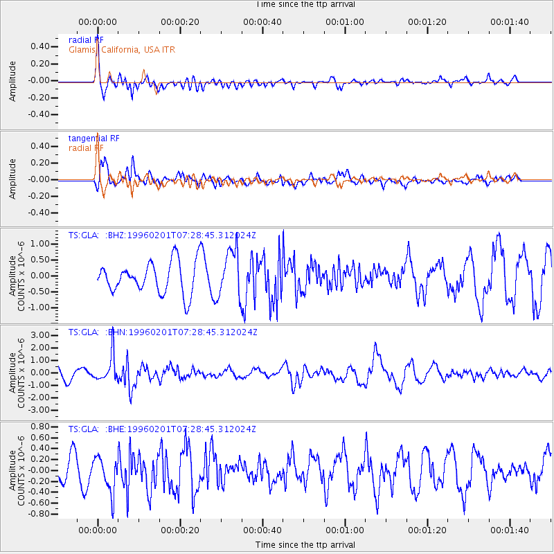
GLA Glamis, California, USA - Earthquake Result Viewer
*The percent match for this event was below the threshold and hence no stack was calculated.
| Earthquake location: |
Kuril Islands |
| Earthquake latitude/longitude: |
44.9/146.3 |
| Earthquake time(UTC): |
1996/02/01 (032) 07:18:05 GMT |
| Earthquake Depth: |
180 km |
| Earthquake Magnitude: |
5.7 MB, 6.2 UNKNOWN, 6.2 MW |
| Earthquake Catalog/Contributor: |
WHDF/NEIC |
|
| Network: |
TS TERRAscope (Southern California Seismic Network) |
| Station: |
GLA Glamis, California, USA |
| Lat/Lon: |
33.05 N/114.83 W |
| Elevation: |
627 m |
|
| Distance: |
73.2 deg |
| Az: |
60.098 deg |
| Baz: |
312.773 deg |
| Ray Param: |
$rayparam |
*The percent match for this event was below the threshold and hence was not used in the summary stack. |
|
| Radial Match: |
67.077576 % |
| Radial Bump: |
400 |
| Transverse Match: |
68.91721 % |
| Transverse Bump: |
400 |
| SOD ConfigId: |
4480 |
| Insert Time: |
2010-02-26 14:14:18.029 +0000 |
| GWidth: |
2.5 |
| Max Bumps: |
400 |
| Tol: |
0.001 |
|
Signal To Noise
| Channel | StoN | STA | LTA |
| TS:GLA: :BHN:19960201T07:28:45.312024Z | 2.8294587 | 1.1262092E-6 | 3.980299E-7 |
| TS:GLA: :BHE:19960201T07:28:45.312024Z | 1.7176882 | 3.466595E-7 | 2.0181749E-7 |
| TS:GLA: :BHZ:19960201T07:28:45.312024Z | 1.5216045 | 7.52529E-7 | 4.945628E-7 |
| Arrivals |
| Ps | |
| PpPs | |
| PsPs/PpSs | |


