You are here: Home > Network List > TA - USArray Transportable Network (new EarthScope stations) Stations List
> Station Y13A Salome, AZ, USA > Earthquake Result Viewer
Y13A Salome, AZ, USA - Earthquake Result Viewer
| Earthquake location: |
Eastern Siberia, Russia |
| Earthquake latitude/longitude: |
60.9/167.1 |
| Earthquake time(UTC): |
2006/04/20 (110) 23:25:02 GMT |
| Earthquake Depth: |
22 km |
| Earthquake Magnitude: |
6.8 MB, 7.6 MS, 7.6 MW, 7.3 MW |
| Earthquake Catalog/Contributor: |
WHDF/NEIC |
|
| Network: |
TA USArray Transportable Network (new EarthScope stations) |
| Station: |
Y13A Salome, AZ, USA |
| Lat/Lon: |
33.81 N/113.83 W |
| Elevation: |
357 m |
|
| Distance: |
55.9 deg |
| Az: |
80.778 deg |
| Baz: |
324.644 deg |
| Ray Param: |
0.06445358 |
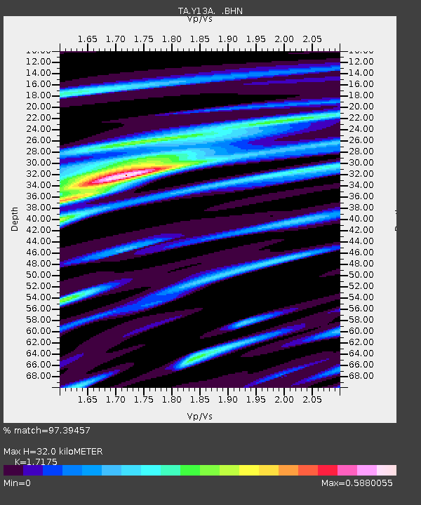
| Estimated Moho Depth: |
32.0 km |
| Estimated Crust Vp/Vs: |
1.72 |
| Assumed Crust Vp: |
6.264 km/s |
| Estimated Crust Vs: |
3.647 km/s |
| Estimated Crust Poisson's Ratio: |
0.24 |
|
| Radial Match: |
97.39457 % |
| Radial Bump: |
390 |
| Transverse Match: |
88.76614 % |
| Transverse Bump: |
400 |
| SOD ConfigId: |
2669 |
| Insert Time: |
2010-03-06 22:59:04.844 +0000 |
| GWidth: |
2.5 |
| Max Bumps: |
400 |
| Tol: |
0.001 |
|

Signal To Noise
| Channel | StoN | STA | LTA |
| TA:Y13A: :BHN:20060420T23:34:07.373999Z | 17.012987 | 3.4326545E-6 | 2.0176671E-7 |
| TA:Y13A: :BHE:20060420T23:34:07.373999Z | 24.136187 | 2.4406634E-6 | 1.011205E-7 |
| TA:Y13A: :BHZ:20060420T23:34:07.373999Z | 52.551495 | 8.093839E-6 | 1.540173E-7 |
| Arrivals |
| Ps | 3.9 SECOND |
| PpPs | 13 SECOND |
| PsPs/PpSs | 17 SECOND |


