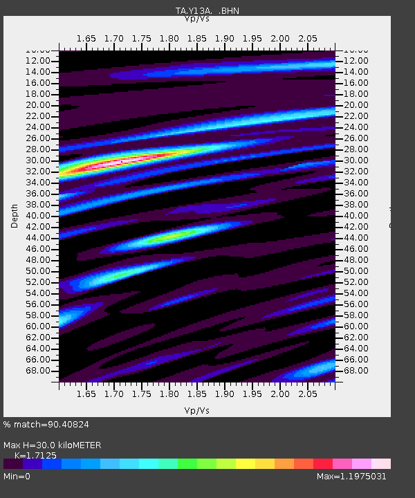
Y13A Salome, AZ, USA - Earthquake Result Viewer
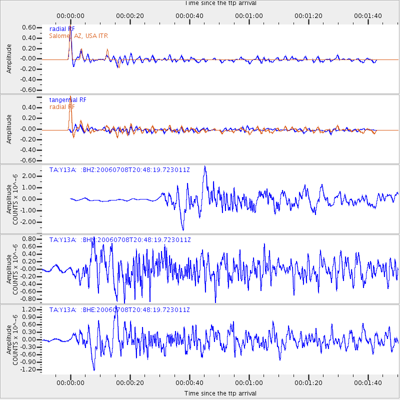
Earthquake location: Andreanof Islands, Aleutian Is.
Earthquake latitude/longitude: 51.2/-179.3
Earthquake time(UTC): 2006/07/08 (189) 20:40:00 GMT
Earthquake Depth: 22 km
Earthquake Magnitude: 6.2 MB, 6.4 MS, 6.6 MW, 6.6 MW
Earthquake Catalog/Contributor: WHDF/NEIC
Network: TA USArray Transportable Network (new EarthScope stations)
Station: Y13A Salome, AZ, USA
Lat/Lon: 33.81 N/113.83 W
Elevation: 357 m
Distance: 49.6 deg
Az: 83.985 deg
Baz: 311.297 deg
Ray Param: 0.068557814
Estimated Moho Depth: 30.0 km
Estimated Crust Vp/Vs: 1.71
Assumed Crust Vp: 6.264 km/s
Estimated Crust Vs: 3.658 km/s
Estimated Crust Poisson's Ratio: 0.24
Radial Match: 90.40824 %
Radial Bump: 400
Transverse Match: 71.60968 %
Transverse Bump: 400
SOD ConfigId: 5423
Insert Time: 2010-03-06 22:59:07.821 +0000
GWidth: 2.5
Max Bumps: 400
Tol: 0.001

Signal To Noise

ChannelStoNSTALTA
TA:Y13A: :BHN:20060708T20:48:19.723011Z3.24742171.4673218E-74.518421E-8
TA:Y13A: :BHE:20060708T20:48:19.723011Z2.67595771.8347433E-76.8563985E-8
TA:Y13A: :BHZ:20060708T20:48:19.723011Z5.0687033.630557E-77.162694E-8
Arrivals
Ps3.6 SECOND
PpPs12 SECOND
PsPs/PpSs16 SECOND