You are here: Home > Network List > OX - North-East Italy Seismic Network Stations List
> Station CGRP Cima Grappa > Earthquake Result Viewer
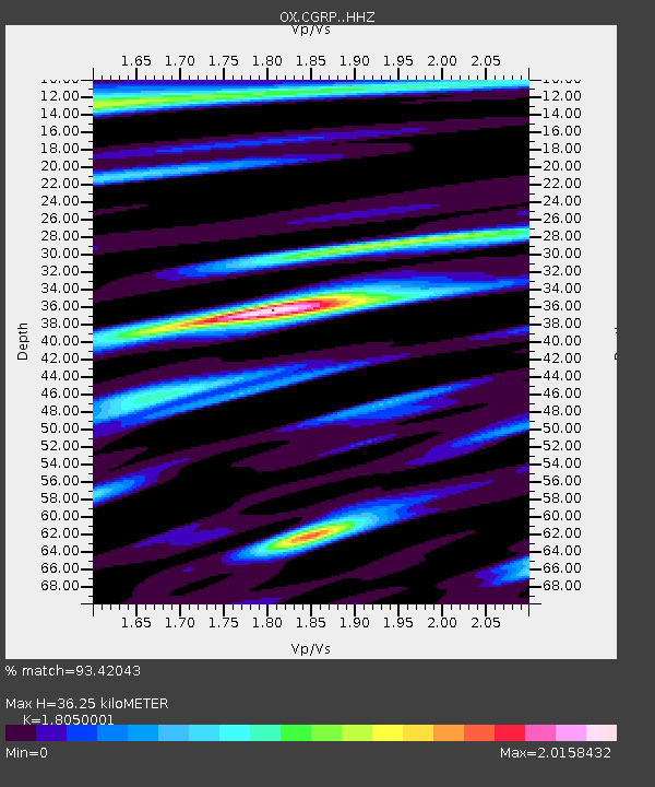
CGRP Cima Grappa - Earthquake Result Viewer
| Earthquake location: |
Northern Peru |
| Earthquake latitude/longitude: |
-5.9/-75.3 |
| Earthquake time(UTC): |
2019/05/26 (146) 07:41:13 GMT |
| Earthquake Depth: |
105 km |
| Earthquake Magnitude: |
7.5 Mi |
| Earthquake Catalog/Contributor: |
NEIC PDE/at |
|
| Network: |
OX North-East Italy Seismic Network |
| Station: |
CGRP Cima Grappa |
| Lat/Lon: |
45.88 N/11.80 E |
| Elevation: |
1757 m |
|
| Distance: |
92.2 deg |
| Az: |
44.281 deg |
| Baz: |
263.837 deg |
| Ray Param: |
0.041453294 |
| Estimated Moho Depth: |
36.25 km |
| Estimated Crust Vp/Vs: |
1.81 |
| Assumed Crust Vp: |
6.155 km/s |
| Estimated Crust Vs: |
3.41 km/s |
| Estimated Crust Poisson's Ratio: |
0.28 |
|
| Radial Match: |
93.42043 % |
| Radial Bump: |
400 |
| Transverse Match: |
86.721695 % |
| Transverse Bump: |
400 |
| SOD ConfigId: |
18369291 |
| Insert Time: |
2019-06-09 07:50:16.231 +0000 |
| GWidth: |
2.5 |
| Max Bumps: |
400 |
| Tol: |
0.001 |
|

Signal To Noise
| Channel | StoN | STA | LTA |
| OX:CGRP: :HHZ:20190526T07:53:39.528015Z | 20.414972 | 3.1596744E-6 | 1.5477241E-7 |
| OX:CGRP: :HHN:20190526T07:53:39.528015Z | 6.4040675 | 5.181328E-7 | 8.090684E-8 |
| OX:CGRP: :HHE:20190526T07:53:39.528015Z | 7.076256 | 1.062461E-6 | 1.5014452E-7 |
| Arrivals |
| Ps | 4.8 SECOND |
| PpPs | 16 SECOND |
| PsPs/PpSs | 21 SECOND |


