You are here: Home > Network List > TA - USArray Transportable Network (new EarthScope stations) Stations List
> Station Y13A Salome, AZ, USA > Earthquake Result Viewer
Y13A Salome, AZ, USA - Earthquake Result Viewer
| Earthquake location: |
Kyushu, Japan |
| Earthquake latitude/longitude: |
33.1/131.1 |
| Earthquake time(UTC): |
2006/06/11 (162) 20:01:26 GMT |
| Earthquake Depth: |
140 km |
| Earthquake Magnitude: |
5.9 MB, 6.3 MW, 6.3 MW |
| Earthquake Catalog/Contributor: |
WHDF/NEIC |
|
| Network: |
TA USArray Transportable Network (new EarthScope stations) |
| Station: |
Y13A Salome, AZ, USA |
| Lat/Lon: |
33.81 N/113.83 W |
| Elevation: |
357 m |
|
| Distance: |
89.7 deg |
| Az: |
48.972 deg |
| Baz: |
310.507 deg |
| Ray Param: |
0.04169898 |
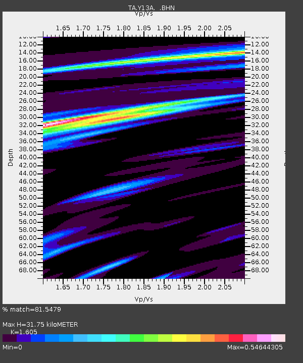
| Estimated Moho Depth: |
31.75 km |
| Estimated Crust Vp/Vs: |
1.61 |
| Assumed Crust Vp: |
6.264 km/s |
| Estimated Crust Vs: |
3.903 km/s |
| Estimated Crust Poisson's Ratio: |
0.18 |
|
| Radial Match: |
81.5479 % |
| Radial Bump: |
400 |
| Transverse Match: |
59.390697 % |
| Transverse Bump: |
400 |
| SOD ConfigId: |
5423 |
| Insert Time: |
2010-03-06 22:59:12.233 +0000 |
| GWidth: |
2.5 |
| Max Bumps: |
400 |
| Tol: |
0.001 |
|

Signal To Noise
| Channel | StoN | STA | LTA |
| TA:Y13A: :BHN:20060611T20:13:37.224001Z | 1.8908036 | 1.4279047E-7 | 7.551841E-8 |
| TA:Y13A: :BHE:20060611T20:13:37.224001Z | 2.28977 | 1.3223972E-7 | 5.7752402E-8 |
| TA:Y13A: :BHZ:20060611T20:13:37.224001Z | 9.419879 | 5.5126947E-7 | 5.8521927E-8 |
| Arrivals |
| Ps | 3.1 SECOND |
| PpPs | 13 SECOND |
| PsPs/PpSs | 16 SECOND |


