You are here: Home > Network List > TA - USArray Transportable Network (new EarthScope stations) Stations List
> Station Y13A Salome, AZ, USA > Earthquake Result Viewer
Y13A Salome, AZ, USA - Earthquake Result Viewer
| Earthquake location: |
Near Coast Of Peru |
| Earthquake latitude/longitude: |
-13.5/-76.7 |
| Earthquake time(UTC): |
2006/10/20 (293) 10:48:56 GMT |
| Earthquake Depth: |
23 km |
| Earthquake Magnitude: |
5.9 MB, 6.6 MS, 6.7 MW, 6.6 MW |
| Earthquake Catalog/Contributor: |
WHDF/NEIC |
|
| Network: |
TA USArray Transportable Network (new EarthScope stations) |
| Station: |
Y13A Salome, AZ, USA |
| Lat/Lon: |
33.81 N/113.83 W |
| Elevation: |
357 m |
|
| Distance: |
58.8 deg |
| Az: |
324.012 deg |
| Baz: |
136.634 deg |
| Ray Param: |
0.06255526 |
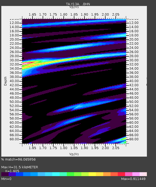
| Estimated Moho Depth: |
31.5 km |
| Estimated Crust Vp/Vs: |
1.61 |
| Assumed Crust Vp: |
6.264 km/s |
| Estimated Crust Vs: |
3.903 km/s |
| Estimated Crust Poisson's Ratio: |
0.18 |
|
| Radial Match: |
96.065956 % |
| Radial Bump: |
293 |
| Transverse Match: |
71.98109 % |
| Transverse Bump: |
400 |
| SOD ConfigId: |
2665 |
| Insert Time: |
2010-03-06 22:59:14.697 +0000 |
| GWidth: |
2.5 |
| Max Bumps: |
400 |
| Tol: |
0.001 |
|

Signal To Noise
| Channel | StoN | STA | LTA |
| TA:Y13A: :BHN:20061020T10:58:21.650015Z | 1.5574389 | 3.3741017E-7 | 2.1664424E-7 |
| TA:Y13A: :BHE:20061020T10:58:21.650015Z | 2.6845841 | 3.397945E-7 | 1.2657249E-7 |
| TA:Y13A: :BHZ:20061020T10:58:21.650015Z | 3.7258806 | 7.938871E-7 | 2.1307368E-7 |
| Arrivals |
| Ps | 3.2 SECOND |
| PpPs | 12 SECOND |
| PsPs/PpSs | 16 SECOND |


