You are here: Home > Network List > TA - USArray Transportable Network (new EarthScope stations) Stations List
> Station Y13A Salome, AZ, USA > Earthquake Result Viewer
Y13A Salome, AZ, USA - Earthquake Result Viewer
| Earthquake location: |
San Juan Province, Argentina |
| Earthquake latitude/longitude: |
-31.7/-67.2 |
| Earthquake time(UTC): |
2006/09/17 (260) 09:34:14 GMT |
| Earthquake Depth: |
142 km |
| Earthquake Magnitude: |
5.7 MB, 6.2 MW, 6.2 MW |
| Earthquake Catalog/Contributor: |
WHDF/NEIC |
|
| Network: |
TA USArray Transportable Network (new EarthScope stations) |
| Station: |
Y13A Salome, AZ, USA |
| Lat/Lon: |
33.81 N/113.83 W |
| Elevation: |
357 m |
|
| Distance: |
78.6 deg |
| Az: |
321.864 deg |
| Baz: |
140.808 deg |
| Ray Param: |
0.049161136 |
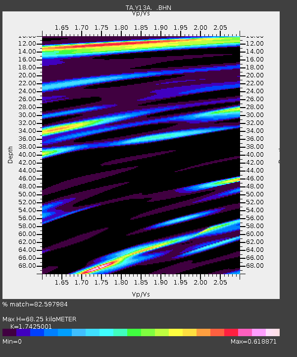
| Estimated Moho Depth: |
68.25 km |
| Estimated Crust Vp/Vs: |
1.74 |
| Assumed Crust Vp: |
6.264 km/s |
| Estimated Crust Vs: |
3.595 km/s |
| Estimated Crust Poisson's Ratio: |
0.25 |
|
| Radial Match: |
82.597984 % |
| Radial Bump: |
400 |
| Transverse Match: |
69.077644 % |
| Transverse Bump: |
400 |
| SOD ConfigId: |
2665 |
| Insert Time: |
2010-03-06 22:59:27.963 +0000 |
| GWidth: |
2.5 |
| Max Bumps: |
400 |
| Tol: |
0.001 |
|
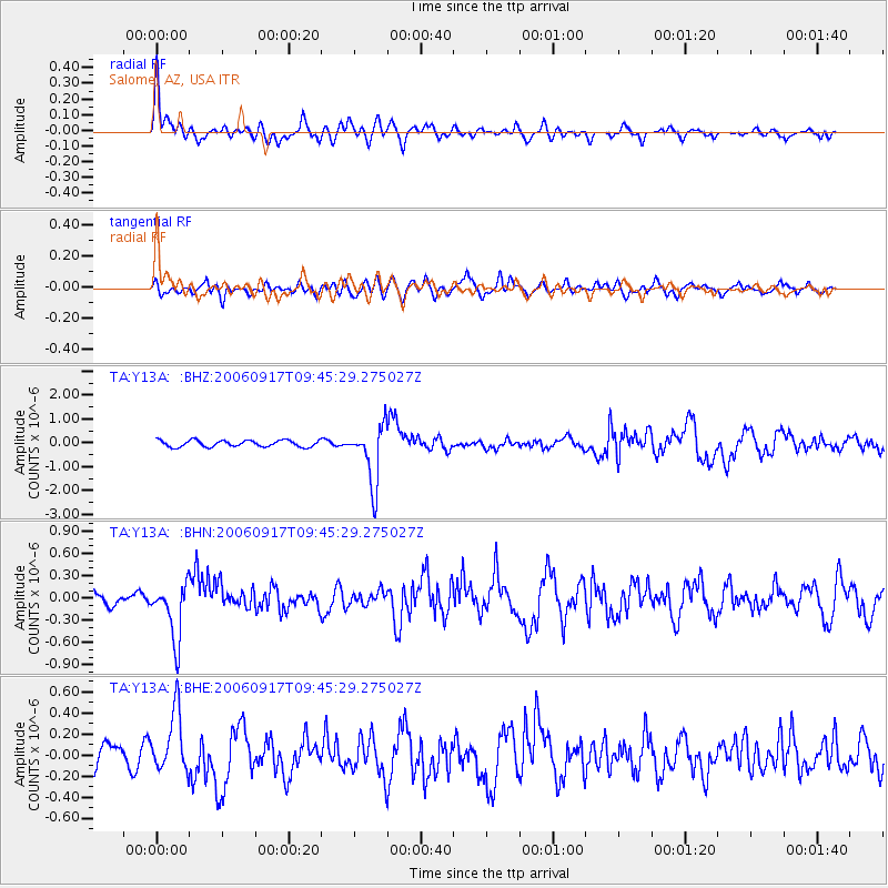
Signal To Noise
| Channel | StoN | STA | LTA |
| TA:Y13A: :BHN:20060917T09:45:29.275027Z | 3.3092046 | 3.8179098E-7 | 1.1537244E-7 |
| TA:Y13A: :BHE:20060917T09:45:29.275027Z | 2.87138 | 2.8676618E-7 | 9.987051E-8 |
| TA:Y13A: :BHZ:20060917T09:45:29.275027Z | 9.003013 | 1.2361375E-6 | 1.3730264E-7 |
| Arrivals |
| Ps | 8.3 SECOND |
| PpPs | 29 SECOND |
| PsPs/PpSs | 37 SECOND |


