You are here: Home > Network List > TA - USArray Transportable Network (new EarthScope stations) Stations List
> Station Y13A Salome, AZ, USA > Earthquake Result Viewer
Y13A Salome, AZ, USA - Earthquake Result Viewer
| Earthquake location: |
Fiji Islands Region |
| Earthquake latitude/longitude: |
-19.9/-178.3 |
| Earthquake time(UTC): |
2006/06/27 (178) 02:59:15 GMT |
| Earthquake Depth: |
570 km |
| Earthquake Magnitude: |
6.0 MB, 6.2 MW |
| Earthquake Catalog/Contributor: |
WHDF/NEIC |
|
| Network: |
TA USArray Transportable Network (new EarthScope stations) |
| Station: |
Y13A Salome, AZ, USA |
| Lat/Lon: |
33.81 N/113.83 W |
| Elevation: |
357 m |
|
| Distance: |
81.3 deg |
| Az: |
49.454 deg |
| Baz: |
239.211 deg |
| Ray Param: |
0.045944985 |
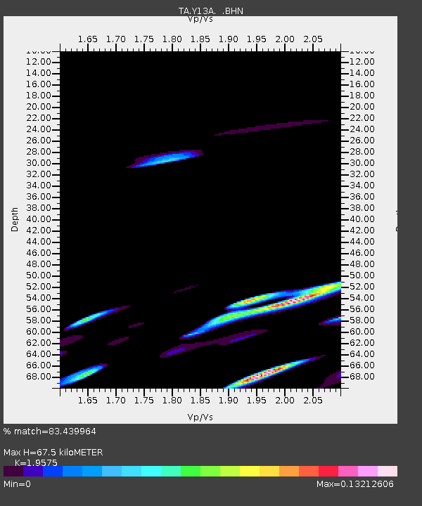
| Estimated Moho Depth: |
67.5 km |
| Estimated Crust Vp/Vs: |
1.96 |
| Assumed Crust Vp: |
6.264 km/s |
| Estimated Crust Vs: |
3.2 km/s |
| Estimated Crust Poisson's Ratio: |
0.32 |
|
| Radial Match: |
83.439964 % |
| Radial Bump: |
400 |
| Transverse Match: |
80.19895 % |
| Transverse Bump: |
400 |
| SOD ConfigId: |
2665 |
| Insert Time: |
2010-03-06 22:59:38.240 +0000 |
| GWidth: |
2.5 |
| Max Bumps: |
400 |
| Tol: |
0.001 |
|

Signal To Noise
| Channel | StoN | STA | LTA |
| TA:Y13A: :BHN:20060627T03:10:01.650027Z | 1.2609204 | 8.37544E-7 | 6.642323E-7 |
| TA:Y13A: :BHE:20060627T03:10:01.650027Z | 1.6392169 | 1.6028049E-6 | 9.77787E-7 |
| TA:Y13A: :BHZ:20060627T03:10:01.650027Z | 2.7060585 | 3.1216905E-6 | 1.1535931E-6 |
| Arrivals |
| Ps | 11 SECOND |
| PpPs | 31 SECOND |
| PsPs/PpSs | 42 SECOND |


