You are here: Home > Network List > TA - USArray Transportable Network (new EarthScope stations) Stations List
> Station C18K Utukok River, AK, USA > Earthquake Result Viewer
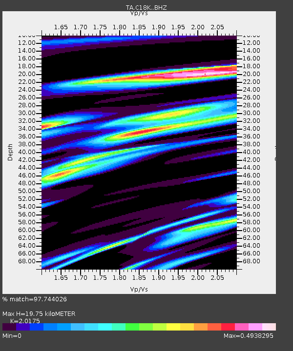
C18K Utukok River, AK, USA - Earthquake Result Viewer
| Earthquake location: |
Northern Peru |
| Earthquake latitude/longitude: |
-5.9/-75.3 |
| Earthquake time(UTC): |
2019/05/26 (146) 07:41:13 GMT |
| Earthquake Depth: |
105 km |
| Earthquake Magnitude: |
7.5 Mi |
| Earthquake Catalog/Contributor: |
NEIC PDE/at |
|
| Network: |
TA USArray Transportable Network (new EarthScope stations) |
| Station: |
C18K Utukok River, AK, USA |
| Lat/Lon: |
68.65 N/161.19 W |
| Elevation: |
845 m |
|
| Distance: |
94.0 deg |
| Az: |
338.522 deg |
| Baz: |
95.965 deg |
| Ray Param: |
0.04109022 |
| Estimated Moho Depth: |
19.75 km |
| Estimated Crust Vp/Vs: |
2.02 |
| Assumed Crust Vp: |
5.906 km/s |
| Estimated Crust Vs: |
2.928 km/s |
| Estimated Crust Poisson's Ratio: |
0.34 |
|
| Radial Match: |
97.744026 % |
| Radial Bump: |
400 |
| Transverse Match: |
93.302666 % |
| Transverse Bump: |
400 |
| SOD ConfigId: |
18369291 |
| Insert Time: |
2019-06-09 07:51:21.269 +0000 |
| GWidth: |
2.5 |
| Max Bumps: |
400 |
| Tol: |
0.001 |
|

Signal To Noise
| Channel | StoN | STA | LTA |
| TA:C18K: :BHZ:20190526T07:53:47.674988Z | 20.29774 | 4.792969E-6 | 2.3613312E-7 |
| TA:C18K: :BHN:20190526T07:53:47.674988Z | 4.729779 | 4.5516015E-7 | 9.623287E-8 |
| TA:C18K: :BHE:20190526T07:53:47.674988Z | 10.6737 | 1.4513658E-6 | 1.3597588E-7 |
| Arrivals |
| Ps | 3.5 SECOND |
| PpPs | 9.9 SECOND |
| PsPs/PpSs | 13 SECOND |


