You are here: Home > Network List > TA - USArray Transportable Network (new EarthScope stations) Stations List
> Station E17K Hotham Inlet, AK, USA > Earthquake Result Viewer
E17K Hotham Inlet, AK, USA - Earthquake Result Viewer
| Earthquake location: |
Northern Peru |
| Earthquake latitude/longitude: |
-5.9/-75.3 |
| Earthquake time(UTC): |
2019/05/26 (146) 07:41:13 GMT |
| Earthquake Depth: |
105 km |
| Earthquake Magnitude: |
7.5 Mi |
| Earthquake Catalog/Contributor: |
NEIC PDE/at |
|
| Network: |
TA USArray Transportable Network (new EarthScope stations) |
| Station: |
E17K Hotham Inlet, AK, USA |
| Lat/Lon: |
67.08 N/161.83 W |
| Elevation: |
233 m |
|
| Distance: |
94.0 deg |
| Az: |
336.928 deg |
| Baz: |
95.491 deg |
| Ray Param: |
0.041071244 |
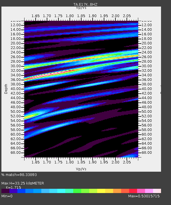
| Estimated Moho Depth: |
33.25 km |
| Estimated Crust Vp/Vs: |
1.72 |
| Assumed Crust Vp: |
6.276 km/s |
| Estimated Crust Vs: |
3.659 km/s |
| Estimated Crust Poisson's Ratio: |
0.24 |
|
| Radial Match: |
98.33893 % |
| Radial Bump: |
362 |
| Transverse Match: |
95.49698 % |
| Transverse Bump: |
400 |
| SOD ConfigId: |
18369291 |
| Insert Time: |
2019-06-09 07:51:31.107 +0000 |
| GWidth: |
2.5 |
| Max Bumps: |
400 |
| Tol: |
0.001 |
|

Signal To Noise
| Channel | StoN | STA | LTA |
| TA:E17K: :BHZ:20190526T07:53:48.049988Z | 21.621218 | 4.784425E-6 | 2.212838E-7 |
| TA:E17K: :BHN:20190526T07:53:48.049988Z | 3.833487 | 2.7346474E-7 | 7.133576E-8 |
| TA:E17K: :BHE:20190526T07:53:48.049988Z | 17.726648 | 1.6267571E-6 | 9.176902E-8 |
| Arrivals |
| Ps | 3.9 SECOND |
| PpPs | 14 SECOND |
| PsPs/PpSs | 18 SECOND |


