You are here: Home > Network List > TA - USArray Transportable Network (new EarthScope stations) Stations List
> Station E22K Anaktuvuk Pass, AK, USA > Earthquake Result Viewer
E22K Anaktuvuk Pass, AK, USA - Earthquake Result Viewer
| Earthquake location: |
Northern Peru |
| Earthquake latitude/longitude: |
-5.9/-75.3 |
| Earthquake time(UTC): |
2019/05/26 (146) 07:41:13 GMT |
| Earthquake Depth: |
105 km |
| Earthquake Magnitude: |
7.5 Mi |
| Earthquake Catalog/Contributor: |
NEIC PDE/at |
|
| Network: |
TA USArray Transportable Network (new EarthScope stations) |
| Station: |
E22K Anaktuvuk Pass, AK, USA |
| Lat/Lon: |
68.13 N/151.81 W |
| Elevation: |
772 m |
|
| Distance: |
90.4 deg |
| Az: |
338.637 deg |
| Baz: |
104.677 deg |
| Ray Param: |
0.041652177 |
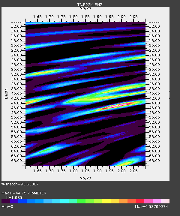
| Estimated Moho Depth: |
44.75 km |
| Estimated Crust Vp/Vs: |
1.99 |
| Assumed Crust Vp: |
6.221 km/s |
| Estimated Crust Vs: |
3.134 km/s |
| Estimated Crust Poisson's Ratio: |
0.33 |
|
| Radial Match: |
93.63307 % |
| Radial Bump: |
400 |
| Transverse Match: |
92.86352 % |
| Transverse Bump: |
400 |
| SOD ConfigId: |
18369291 |
| Insert Time: |
2019-06-09 07:51:34.239 +0000 |
| GWidth: |
2.5 |
| Max Bumps: |
400 |
| Tol: |
0.001 |
|

Signal To Noise
| Channel | StoN | STA | LTA |
| TA:E22K: :BHZ:20190526T07:53:31.549988Z | 21.200157 | 6.4400942E-6 | 3.0377578E-7 |
| TA:E22K: :BHN:20190526T07:53:31.549988Z | 3.5222437 | 2.9256992E-7 | 8.3063505E-8 |
| TA:E22K: :BHE:20190526T07:53:31.549988Z | 15.561914 | 1.9865047E-6 | 1.2765169E-7 |
| Arrivals |
| Ps | 7.2 SECOND |
| PpPs | 21 SECOND |
| PsPs/PpSs | 28 SECOND |


