You are here: Home > Network List > TA - USArray Transportable Network (new EarthScope stations) Stations List
> Station Y13A Salome, AZ, USA > Earthquake Result Viewer
Y13A Salome, AZ, USA - Earthquake Result Viewer
| Earthquake location: |
Vanuatu Islands |
| Earthquake latitude/longitude: |
-15.1/167.4 |
| Earthquake time(UTC): |
2006/04/30 (120) 08:17:34 GMT |
| Earthquake Depth: |
128 km |
| Earthquake Magnitude: |
5.4 MB, 6.1 MW, 6.1 MW |
| Earthquake Catalog/Contributor: |
WHDF/NEIC |
|
| Network: |
TA USArray Transportable Network (new EarthScope stations) |
| Station: |
Y13A Salome, AZ, USA |
| Lat/Lon: |
33.81 N/113.83 W |
| Elevation: |
357 m |
|
| Distance: |
89.2 deg |
| Az: |
54.745 deg |
| Baz: |
251.327 deg |
| Ray Param: |
0.04174677 |
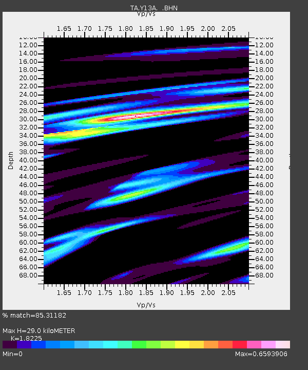
| Estimated Moho Depth: |
29.0 km |
| Estimated Crust Vp/Vs: |
1.82 |
| Assumed Crust Vp: |
6.264 km/s |
| Estimated Crust Vs: |
3.437 km/s |
| Estimated Crust Poisson's Ratio: |
0.28 |
|
| Radial Match: |
85.31182 % |
| Radial Bump: |
391 |
| Transverse Match: |
68.73924 % |
| Transverse Bump: |
400 |
| SOD ConfigId: |
2669 |
| Insert Time: |
2010-03-06 22:59:51.643 +0000 |
| GWidth: |
2.5 |
| Max Bumps: |
400 |
| Tol: |
0.001 |
|

Signal To Noise
| Channel | StoN | STA | LTA |
| TA:Y13A: :BHN:20060430T08:29:45.050002Z | 1.3646156 | 1.05243444E-7 | 7.712315E-8 |
| TA:Y13A: :BHE:20060430T08:29:45.050002Z | 3.1809149 | 2.615986E-7 | 8.224005E-8 |
| TA:Y13A: :BHZ:20060430T08:29:45.050002Z | 6.047407 | 6.42833E-7 | 1.0629895E-7 |
| Arrivals |
| Ps | 3.9 SECOND |
| PpPs | 13 SECOND |
| PsPs/PpSs | 17 SECOND |


