You are here: Home > Network List > TA - USArray Transportable Network (new EarthScope stations) Stations List
> Station G21K Allakaket, AK, USA > Earthquake Result Viewer
G21K Allakaket, AK, USA - Earthquake Result Viewer
| Earthquake location: |
Northern Peru |
| Earthquake latitude/longitude: |
-5.9/-75.3 |
| Earthquake time(UTC): |
2019/05/26 (146) 07:41:13 GMT |
| Earthquake Depth: |
105 km |
| Earthquake Magnitude: |
7.5 Mi |
| Earthquake Catalog/Contributor: |
NEIC PDE/at |
|
| Network: |
TA USArray Transportable Network (new EarthScope stations) |
| Station: |
G21K Allakaket, AK, USA |
| Lat/Lon: |
66.52 N/153.51 W |
| Elevation: |
446 m |
|
| Distance: |
90.7 deg |
| Az: |
336.901 deg |
| Baz: |
103.134 deg |
| Ray Param: |
0.041634623 |
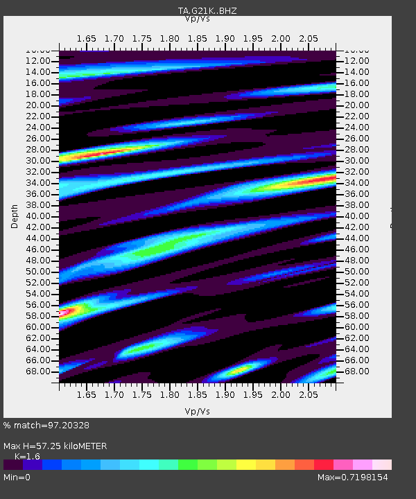
| Estimated Moho Depth: |
57.25 km |
| Estimated Crust Vp/Vs: |
1.60 |
| Assumed Crust Vp: |
6.455 km/s |
| Estimated Crust Vs: |
4.035 km/s |
| Estimated Crust Poisson's Ratio: |
0.18 |
|
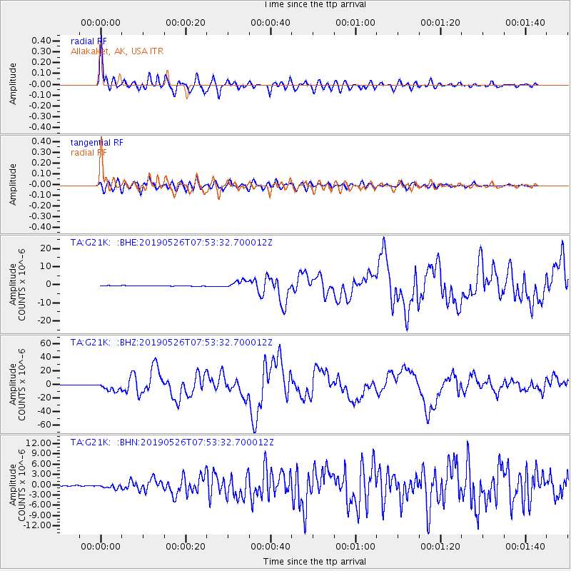
| Radial Match: |
97.20328 % |
| Radial Bump: |
400 |
| Transverse Match: |
84.21444 % |
| Transverse Bump: |
400 |
| SOD ConfigId: |
18369291 |
| Insert Time: |
2019-06-09 07:51:48.359 +0000 |
| GWidth: |
2.5 |
| Max Bumps: |
400 |
| Tol: |
0.001 |
|
Signal To Noise
| Channel | StoN | STA | LTA |
| TA:G21K: :BHZ:20190526T07:53:32.700012Z | 21.79797 | 6.308845E-6 | 2.894235E-7 |
| TA:G21K: :BHN:20190526T07:53:32.700012Z | 5.214218 | 5.4533234E-7 | 1.0458564E-7 |
| TA:G21K: :BHE:20190526T07:53:32.700012Z | 15.951301 | 2.1342948E-6 | 1.3380068E-7 |
| Arrivals |
| Ps | 5.4 SECOND |
| PpPs | 23 SECOND |
| PsPs/PpSs | 28 SECOND |


