You are here: Home > Network List > TA - USArray Transportable Network (new EarthScope stations) Stations List
> Station H18K Honhosa River, AK, USA > Earthquake Result Viewer
H18K Honhosa River, AK, USA - Earthquake Result Viewer
| Earthquake location: |
Northern Peru |
| Earthquake latitude/longitude: |
-5.9/-75.3 |
| Earthquake time(UTC): |
2019/05/26 (146) 07:41:13 GMT |
| Earthquake Depth: |
105 km |
| Earthquake Magnitude: |
7.5 Mi |
| Earthquake Catalog/Contributor: |
NEIC PDE/at |
|
| Network: |
TA USArray Transportable Network (new EarthScope stations) |
| Station: |
H18K Honhosa River, AK, USA |
| Lat/Lon: |
65.15 N/158.36 W |
| Elevation: |
494 m |
|
| Distance: |
92.4 deg |
| Az: |
335.178 deg |
| Baz: |
98.753 deg |
| Ray Param: |
0.041410044 |
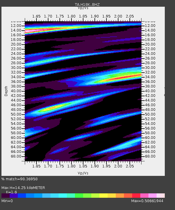
| Estimated Moho Depth: |
14.25 km |
| Estimated Crust Vp/Vs: |
1.60 |
| Assumed Crust Vp: |
6.1 km/s |
| Estimated Crust Vs: |
3.812 km/s |
| Estimated Crust Poisson's Ratio: |
0.18 |
|
| Radial Match: |
98.36958 % |
| Radial Bump: |
381 |
| Transverse Match: |
91.81003 % |
| Transverse Bump: |
400 |
| SOD ConfigId: |
18369291 |
| Insert Time: |
2019-06-09 07:51:54.646 +0000 |
| GWidth: |
2.5 |
| Max Bumps: |
400 |
| Tol: |
0.001 |
|

Signal To Noise
| Channel | StoN | STA | LTA |
| TA:H18K: :BHZ:20190526T07:53:40.549988Z | 21.063423 | 6.6600883E-6 | 3.1619211E-7 |
| TA:H18K: :BHN:20190526T07:53:40.549988Z | 2.9225216 | 3.502532E-7 | 1.1984623E-7 |
| TA:H18K: :BHE:20190526T07:53:40.549988Z | 18.01384 | 2.028576E-6 | 1.1261209E-7 |
| Arrivals |
| Ps | 1.4 SECOND |
| PpPs | 6.0 SECOND |
| PsPs/PpSs | 7.4 SECOND |


