You are here: Home > Network List > TA - USArray Transportable Network (new EarthScope stations) Stations List
> Station I26K Coal Creek Mining Camp, AK, USA > Earthquake Result Viewer
I26K Coal Creek Mining Camp, AK, USA - Earthquake Result Viewer
| Earthquake location: |
Northern Peru |
| Earthquake latitude/longitude: |
-5.9/-75.3 |
| Earthquake time(UTC): |
2019/05/26 (146) 07:41:13 GMT |
| Earthquake Depth: |
105 km |
| Earthquake Magnitude: |
7.5 Mi |
| Earthquake Catalog/Contributor: |
NEIC PDE/at |
|
| Network: |
TA USArray Transportable Network (new EarthScope stations) |
| Station: |
I26K Coal Creek Mining Camp, AK, USA |
| Lat/Lon: |
65.31 N/143.15 W |
| Elevation: |
338 m |
|
| Distance: |
86.3 deg |
| Az: |
337.051 deg |
| Baz: |
112.582 deg |
| Ray Param: |
0.04394264 |
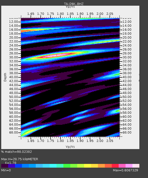
| Estimated Moho Depth: |
28.75 km |
| Estimated Crust Vp/Vs: |
1.78 |
| Assumed Crust Vp: |
6.566 km/s |
| Estimated Crust Vs: |
3.689 km/s |
| Estimated Crust Poisson's Ratio: |
0.27 |
|
| Radial Match: |
98.02382 % |
| Radial Bump: |
400 |
| Transverse Match: |
82.048225 % |
| Transverse Bump: |
400 |
| SOD ConfigId: |
18369291 |
| Insert Time: |
2019-06-09 07:52:03.234 +0000 |
| GWidth: |
2.5 |
| Max Bumps: |
400 |
| Tol: |
0.001 |
|

Signal To Noise
| Channel | StoN | STA | LTA |
| TA:I26K: :BHZ:20190526T07:53:11.900024Z | 23.902248 | 8.780991E-6 | 3.6737097E-7 |
| TA:I26K: :BHN:20190526T07:53:11.900024Z | 11.217842 | 1.1711828E-6 | 1.0440357E-7 |
| TA:I26K: :BHE:20190526T07:53:11.900024Z | 22.210526 | 3.3304448E-6 | 1.4994895E-7 |
| Arrivals |
| Ps | 3.5 SECOND |
| PpPs | 12 SECOND |
| PsPs/PpSs | 15 SECOND |


