You are here: Home > Network List > TA - USArray Transportable Network (new EarthScope stations) Stations List
> Station L17A Cokeville, WY, USA > Earthquake Result Viewer
L17A Cokeville, WY, USA - Earthquake Result Viewer
| Earthquake location: |
Dodecanese Islands, Greece |
| Earthquake latitude/longitude: |
35.8/27.9 |
| Earthquake time(UTC): |
2008/07/15 (197) 03:26:34 GMT |
| Earthquake Depth: |
52 km |
| Earthquake Magnitude: |
6.5 MB, 6.4 MW, 6.4 MW |
| Earthquake Catalog/Contributor: |
WHDF/NEIC |
|
| Network: |
TA USArray Transportable Network (new EarthScope stations) |
| Station: |
L17A Cokeville, WY, USA |
| Lat/Lon: |
42.10 N/110.87 W |
| Elevation: |
1996 m |
|
| Distance: |
93.8 deg |
| Az: |
330.533 deg |
| Baz: |
32.503 deg |
| Ray Param: |
0.041171335 |
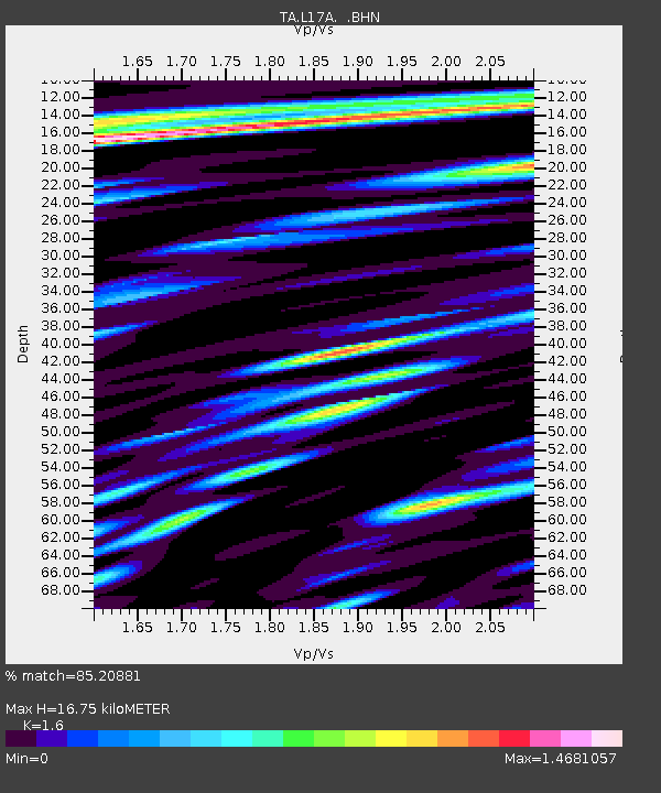
| Estimated Moho Depth: |
16.75 km |
| Estimated Crust Vp/Vs: |
1.60 |
| Assumed Crust Vp: |
6.207 km/s |
| Estimated Crust Vs: |
3.879 km/s |
| Estimated Crust Poisson's Ratio: |
0.18 |
|
| Radial Match: |
85.20881 % |
| Radial Bump: |
400 |
| Transverse Match: |
85.55374 % |
| Transverse Bump: |
400 |
| SOD ConfigId: |
2504 |
| Insert Time: |
2010-03-06 23:00:02.646 +0000 |
| GWidth: |
2.5 |
| Max Bumps: |
400 |
| Tol: |
0.001 |
|
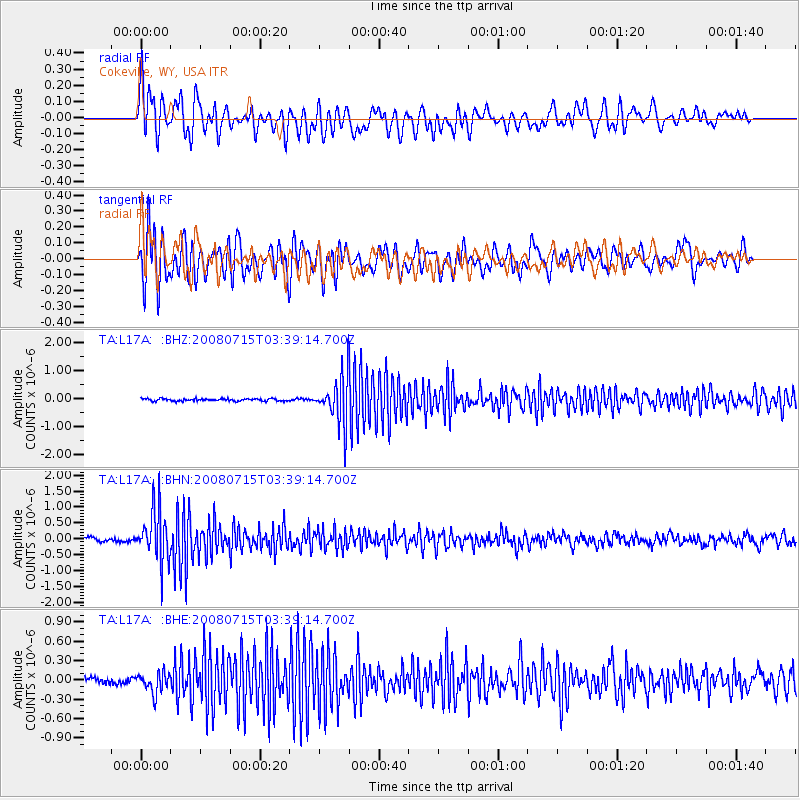
Signal To Noise
| Channel | StoN | STA | LTA |
| TA:L17A: :BHN:20080715T03:39:14.700Z | 9.319225 | 8.05676E-7 | 8.645311E-8 |
| TA:L17A: :BHE:20080715T03:39:14.700Z | 3.0520475 | 1.5926719E-7 | 5.218372E-8 |
| TA:L17A: :BHZ:20080715T03:39:14.700Z | 19.876255 | 8.2095136E-7 | 4.130312E-8 |
| Arrivals |
| Ps | 1.7 SECOND |
| PpPs | 6.9 SECOND |
| PsPs/PpSs | 8.5 SECOND |


