You are here: Home > Network List > TA - USArray Transportable Network (new EarthScope stations) Stations List
> Station P08K Saint George Island, AK, USA > Earthquake Result Viewer
P08K Saint George Island, AK, USA - Earthquake Result Viewer
| Earthquake location: |
Northern Peru |
| Earthquake latitude/longitude: |
-5.9/-75.3 |
| Earthquake time(UTC): |
2019/05/26 (146) 07:41:13 GMT |
| Earthquake Depth: |
105 km |
| Earthquake Magnitude: |
7.5 Mi |
| Earthquake Catalog/Contributor: |
NEIC PDE/at |
|
| Network: |
TA USArray Transportable Network (new EarthScope stations) |
| Station: |
P08K Saint George Island, AK, USA |
| Lat/Lon: |
56.60 N/169.55 W |
| Elevation: |
36 m |
|
| Distance: |
97.2 deg |
| Az: |
326.224 deg |
| Baz: |
89.716 deg |
| Ray Param: |
0.040193312 |
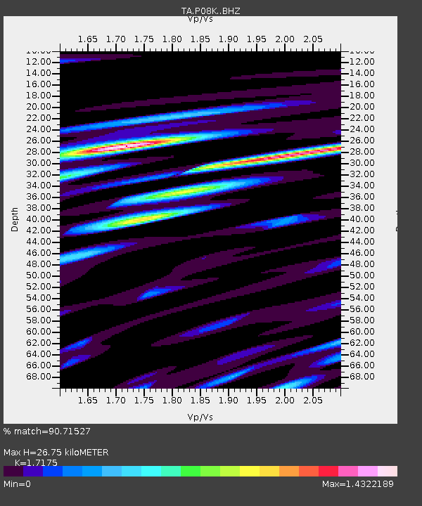
| Estimated Moho Depth: |
26.75 km |
| Estimated Crust Vp/Vs: |
1.72 |
| Assumed Crust Vp: |
6.24 km/s |
| Estimated Crust Vs: |
3.633 km/s |
| Estimated Crust Poisson's Ratio: |
0.24 |
|
| Radial Match: |
90.71527 % |
| Radial Bump: |
400 |
| Transverse Match: |
61.110527 % |
| Transverse Bump: |
400 |
| SOD ConfigId: |
18369291 |
| Insert Time: |
2019-06-09 07:52:40.156 +0000 |
| GWidth: |
2.5 |
| Max Bumps: |
400 |
| Tol: |
0.001 |
|
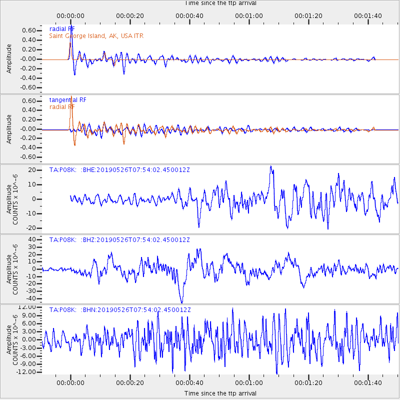
Signal To Noise
| Channel | StoN | STA | LTA |
| TA:P08K: :BHZ:20190526T07:54:02.450012Z | 2.5273376 | 3.3671486E-6 | 1.3322908E-6 |
| TA:P08K: :BHN:20190526T07:54:02.450012Z | 0.94271934 | 2.1916235E-6 | 2.324789E-6 |
| TA:P08K: :BHE:20190526T07:54:02.450012Z | 1.0156845 | 2.0913578E-6 | 2.0590624E-6 |
| Arrivals |
| Ps | 3.1 SECOND |
| PpPs | 11 SECOND |
| PsPs/PpSs | 15 SECOND |


