You are here: Home > Network List > TA - USArray Transportable Network (new EarthScope stations) Stations List
> Station P23K Montague Island, AK, USA > Earthquake Result Viewer
P23K Montague Island, AK, USA - Earthquake Result Viewer
| Earthquake location: |
Northern Peru |
| Earthquake latitude/longitude: |
-5.9/-75.3 |
| Earthquake time(UTC): |
2019/05/26 (146) 07:41:13 GMT |
| Earthquake Depth: |
105 km |
| Earthquake Magnitude: |
7.5 Mi |
| Earthquake Catalog/Contributor: |
NEIC PDE/at |
|
| Network: |
TA USArray Transportable Network (new EarthScope stations) |
| Station: |
P23K Montague Island, AK, USA |
| Lat/Lon: |
60.00 N/147.40 W |
| Elevation: |
287 m |
|
| Distance: |
86.3 deg |
| Az: |
331.363 deg |
| Baz: |
108.438 deg |
| Ray Param: |
0.04396288 |
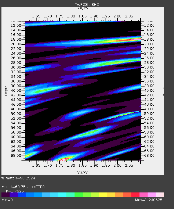
| Estimated Moho Depth: |
69.75 km |
| Estimated Crust Vp/Vs: |
1.76 |
| Assumed Crust Vp: |
5.989 km/s |
| Estimated Crust Vs: |
3.398 km/s |
| Estimated Crust Poisson's Ratio: |
0.26 |
|
| Radial Match: |
90.2524 % |
| Radial Bump: |
400 |
| Transverse Match: |
87.26725 % |
| Transverse Bump: |
400 |
| SOD ConfigId: |
18369291 |
| Insert Time: |
2019-06-09 07:52:42.619 +0000 |
| GWidth: |
2.5 |
| Max Bumps: |
400 |
| Tol: |
0.001 |
|

Signal To Noise
| Channel | StoN | STA | LTA |
| TA:P23K: :BHZ:20190526T07:53:11.750Z | 11.980694 | 9.196054E-6 | 7.675727E-7 |
| TA:P23K: :BHN:20190526T07:53:11.750Z | 2.0404425 | 1.5914437E-6 | 7.799503E-7 |
| TA:P23K: :BHE:20190526T07:53:11.750Z | 4.3945136 | 3.516487E-6 | 8.0019936E-7 |
| Arrivals |
| Ps | 9.1 SECOND |
| PpPs | 32 SECOND |
| PsPs/PpSs | 41 SECOND |


