You are here: Home > Network List > TA - USArray Transportable Network (new EarthScope stations) Stations List
> Station L17A Cokeville, WY, USA > Earthquake Result Viewer
L17A Cokeville, WY, USA - Earthquake Result Viewer
| Earthquake location: |
Chile-Bolivia Border Region |
| Earthquake latitude/longitude: |
-20.0/-69.0 |
| Earthquake time(UTC): |
2008/03/24 (084) 20:39:07 GMT |
| Earthquake Depth: |
120 km |
| Earthquake Magnitude: |
5.7 MB, 6.2 MW, 6.1 MW |
| Earthquake Catalog/Contributor: |
WHDF/NEIC |
|
| Network: |
TA USArray Transportable Network (new EarthScope stations) |
| Station: |
L17A Cokeville, WY, USA |
| Lat/Lon: |
42.10 N/110.87 W |
| Elevation: |
1996 m |
|
| Distance: |
73.0 deg |
| Az: |
328.671 deg |
| Baz: |
138.94 deg |
| Ray Param: |
0.053027004 |
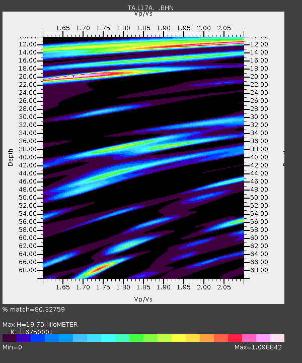
| Estimated Moho Depth: |
19.75 km |
| Estimated Crust Vp/Vs: |
1.68 |
| Assumed Crust Vp: |
6.207 km/s |
| Estimated Crust Vs: |
3.706 km/s |
| Estimated Crust Poisson's Ratio: |
0.22 |
|
| Radial Match: |
80.32759 % |
| Radial Bump: |
400 |
| Transverse Match: |
68.76103 % |
| Transverse Bump: |
400 |
| SOD ConfigId: |
2564 |
| Insert Time: |
2010-03-06 23:00:22.674 +0000 |
| GWidth: |
2.5 |
| Max Bumps: |
400 |
| Tol: |
0.001 |
|
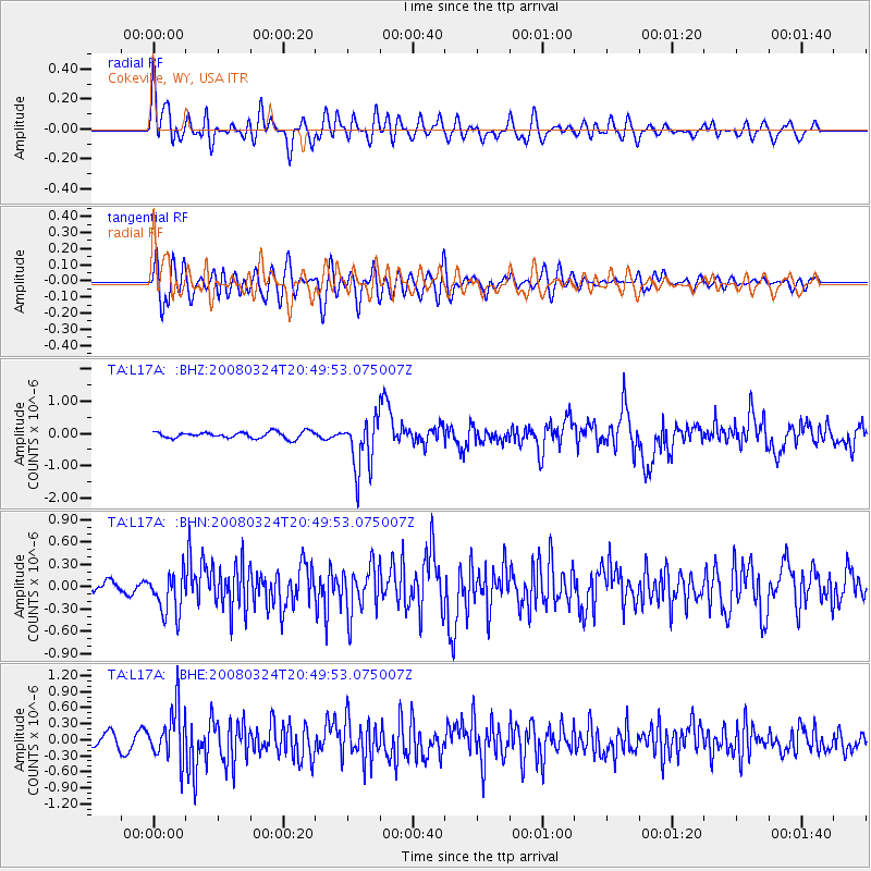
Signal To Noise
| Channel | StoN | STA | LTA |
| TA:L17A: :BHN:20080324T20:49:53.075007Z | 2.186226 | 2.8588875E-7 | 1.3076816E-7 |
| TA:L17A: :BHE:20080324T20:49:53.075007Z | 5.1380725 | 4.866545E-7 | 9.471539E-8 |
| TA:L17A: :BHZ:20080324T20:49:53.075007Z | 8.116496 | 8.2499315E-7 | 1.01644005E-7 |
| Arrivals |
| Ps | 2.2 SECOND |
| PpPs | 8.2 SECOND |
| PsPs/PpSs | 10 SECOND |


