You are here: Home > Network List > TA - USArray Transportable Network (new EarthScope stations) Stations List
> Station Q16K King Salmon, AK, USA > Earthquake Result Viewer
Q16K King Salmon, AK, USA - Earthquake Result Viewer
| Earthquake location: |
Northern Peru |
| Earthquake latitude/longitude: |
-5.9/-75.3 |
| Earthquake time(UTC): |
2019/05/26 (146) 07:41:13 GMT |
| Earthquake Depth: |
105 km |
| Earthquake Magnitude: |
7.5 Mi |
| Earthquake Catalog/Contributor: |
NEIC PDE/at |
|
| Network: |
TA USArray Transportable Network (new EarthScope stations) |
| Station: |
Q16K King Salmon, AK, USA |
| Lat/Lon: |
58.68 N/156.66 W |
| Elevation: |
22 m |
|
| Distance: |
90.5 deg |
| Az: |
328.903 deg |
| Baz: |
100.419 deg |
| Ray Param: |
0.041647308 |
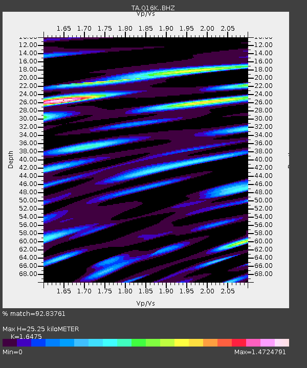
| Estimated Moho Depth: |
25.25 km |
| Estimated Crust Vp/Vs: |
1.65 |
| Assumed Crust Vp: |
6.276 km/s |
| Estimated Crust Vs: |
3.809 km/s |
| Estimated Crust Poisson's Ratio: |
0.21 |
|
| Radial Match: |
92.83761 % |
| Radial Bump: |
400 |
| Transverse Match: |
90.055435 % |
| Transverse Bump: |
400 |
| SOD ConfigId: |
18369291 |
| Insert Time: |
2019-06-09 07:52:46.063 +0000 |
| GWidth: |
2.5 |
| Max Bumps: |
400 |
| Tol: |
0.001 |
|

Signal To Noise
| Channel | StoN | STA | LTA |
| TA:Q16K: :BHZ:20190526T07:53:31.875Z | 18.98507 | 9.268388E-6 | 4.881935E-7 |
| TA:Q16K: :BHN:20190526T07:53:31.875Z | 1.9206765 | 1.2458543E-6 | 6.486539E-7 |
| TA:Q16K: :BHE:20190526T07:53:31.875Z | 4.0203857 | 3.3166293E-6 | 8.24953E-7 |
| Arrivals |
| Ps | 2.7 SECOND |
| PpPs | 10 SECOND |
| PsPs/PpSs | 13 SECOND |


